
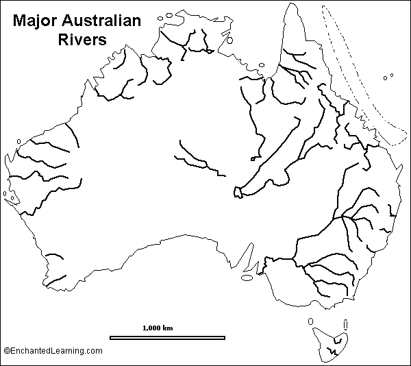
Can you name a river in Australia? No Aussies can answer the question. Just the rest of you on the planet. Other than Antarctica, no continent on this planet is more bereft of flowing surface freshwater than Australia. The largest rivers on the continent (see outline map below) can be found in its eastern half. Smaller river systems hug the northern and northwest coastal regions. And in the centre, Australia is largely desert. The overall picture, therefore, is of a very dry continent.
So how will the forces of climate change impact the behaviour of watersheds in Australia?
Murray-Darling River System – by far the largest of Australia’s watersheds it includes the Murray, Darling, Murrumbidgee, Lachlan and Billabong. It’s the big south flowing river to the right on the map displayed above. The Murray-Darling’s rain-fed watershed extends 1,059,000 square kilometers (658,000 square miles). The basin drains from highland and mountainous areas and across four of Australia’s states including a substantial part of southern Queensland, much of the interior of New South Wales and of Victoria and a small portion of South Australia. It empties into the Indian Ocean near Adelaide, Australia’s fifth largest city. That city draws 8% of its daily water requirements from the Murray-Darling but future plans include building desalination plants in anticipation of declining river flow.
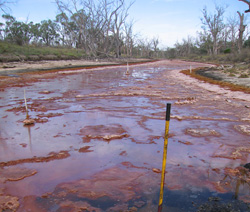
That is because the Murray-Darling, as major river systems go, is probably the driest on the planet and its water level and quality is further exacerbated by human activity. Demands on the watershed have depleted river flow and nearby groundwater sources, impacted wetlands, increased soil salinity, and create a unique problem, acid sulfate soils that contain concentrations of iron sulfide. Acid sulfate has introduced high levels of heavy metals in drinking water, de-oxygenation of surface water, damaged wetlands (see image below) and dangerous releases of noxious gases. All of this has happened because of human activity and now, as Australian scientists study changes to precipitation patterns, climate change.
The South Eastern Australian Climate Initiative was formed to study the impact of climate on the Murray-Darling. According to its preliminary conclusions, “that the climate in south-eastern Australia is shifting,” the region, which has experienced unprecedented drought in the first decade of the 21st century, will continue to see rainfall declines, more intense weather events, potential for flash floods and depleted river flow leading to the drying out of the riverbed in many areas along its course. When you consider the latest outbreak of wildfires to the west and south of Sydney, Australia’s largest city, this may be a forecast of future weather fed events indicative of climate change at work.
Rivers of Queensland – Back in 2011 Australia’s third largest city, Brisbane, was inundated with floodwaters with pictures of the disaster beamed around the world. Again in January of this year Brisbane saw floodwaters inundate 3,600 homes and 1,250 businesses in the city. The source of thse floods is the Brisbane River system which includes the Bremer River and Lockyer Creek. This watershed has frequently exceeded its capacity throughout the city’s history. The Brisbane by continental river system standards is small, a mere 344 kilometers (214 miles) and yet it is the longest river in southern Queensland. But it is also vulnerable to fluctuations in precipitation because of geography and weather patterns. The flooding events predicted by climate change scientists are expected to decrease slightly as Australia continues to dry out with decreases in winter and spring rainfall expected. Overall precipitation is trending to decline by 10% by the year 2030 and 35% by 2070. This is not the forecast for the northern river systems of Queensland with climate change models indicating increases in precipitation. Unfortunately this is not where Australia’s population centers are located.
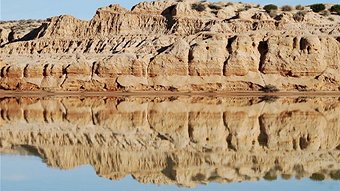
Rivers of Central Australia – The Northern Territory, parts of South Australia and Queensland and the interior of Western Australia constitute this zone of intermittent rivers that drain into seasonal wetlands and lakes before drying out. This arid zone covers 60% of Australia and is dominated by the Lake Eyre watershed. Although this area on the above map appears as rivers terminating in an inland lake it in fact has no permanent flow except in areas where underground springs appear. The terminus, Lake Eyre, is a salt flat that occasionally fills (see picture below). The first historic recording of the lake filling occurred in 1949, more than one hundred years after its discovery. Since that time it has repeatedly gone dry. Current precipitation for the watershed amounts to less than 150 millimeters (5/8 inches) per year.
But even in this water parched basin human activity is threatening to further diminish intermittent flows by tapping into the springs and creating catchments to hold back the water for irrigation and consumption. Already among the hottest places on the planet climate change forecasts indicate a doubling of days above 40 Celsius (105 Fahrenheit) degrees by 2070. This will increase evapotranspiration rates with a decline in the amount of intermittent surface water.
Rivers of Western Australia – This area features Mediterranean and desert climates with the rivers flowing into the Indian Ocean. Notable rivers include the Margaret, Swan, Murchison, and Gascoyne.
The Margaret flows a mere 60 kilometers (37 miles) but is a centre for viticulture in the southwestern corner of the continent. It is the river on the left at the very bottom of the above map. Today the climate is akin to the wine regions of South Africa and California (a Mediterranean climate) with most rainfall falling in the winter.
The Swan is the river that flows through Perth, Australia’s fourth largest and fastest growing city. A mere 60 kilometers (37 miles) in length, it too is located in a Mediterranean climate zone. The tributaries of the river have been dammed to collect freshwater for urban use. To deal with growing water demand Perth has built desalination plants. The latter now supplies 17% of the city’s water supply.
The Murchison is Western Australia’s second longest river at 820 kilometers (510 miles). An intermittent river that flows about half the year much of the river basin features salt lakes and pans.
The Gascoyne is Western Australia’s longest river extending 865 kilometers (537 miles). Located halfway up the western coast the Gascoyne flows intermittently, about 120 days per year. Much of the water disappears into a subterranean aquifer. Rainfall has been declining in the southwestern part of Australia where the Margaret, Swan, Murchison, and Gascoyne flow, and this trend is expected to continue with atmospheric warming.
Rivers of Northern Australia – In this discussion we will look at five rivers emptying into the northern oceans and seas off Australia. These include the Fitzroy, Ord, Daly, Flinders and Gilbert-Einasleigh. All these rivers are located in Australia’s tropical zone.
There are two Fitzroy Rivers in Australia. One in Queensland and the one described here. About 733 kilometers (455 miles) in length the river has been dammed to control frequent floods. It has become a supplementary freshwater source for local communities and is even being used to pipe water as far south as Perth.
The Ord River is a fast flowing 650 kilometer (400 mile) long river in the northeastern part of Western Australia. On average the river basin receives 750 millimeters or 29.5 inches of precipitation annually. At its source the region is much drier with rainfall of 450 millimeters or 17.7 inches. Dammed for irrigation, the Ord features Australia’s largest artificial lake, Lake Argyle. Its tropical wetlands are among the most extensive in Australia. Rainfall is subject to the seasonal strength of the annual monsoon.
The Daly River in Australia’s Northern Territory is the shortest of the rivers described here. It flows 320 kilometers (200 miles) from its source to the Timor Sea and like the Ord is subject to highly variable precipitation and therefore flooding.
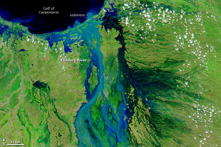
The Flinders is located in Queensland but flows north to the Gulf of Carpenteria. The Flinders is one of Australia’s longest rivers at 1,004 kilometers (622 miles). Hot, wet summers produce variable precipitation with rainfall as low as 350 millimeters (13.8 inches) or as high as 1,200 millimeters (47 inches) depending on the strength of the annual monsoon. The river is prone to flooding and can expand to a width of 100 kilometers (62 miles) when at peak (see satellite image) . Recent floods include 2009 and 2012.
The Gilbert-Einasleigh is located to the north of the Flinders in Queensland. It is 610 kilometers (380 miles) and like the Flinders is subject to the intensity of the annual monsoon which can increase water volume by a factor of 10 from periods of low water during dry season.
What will climate change do to all of these north flowing Australian rivers? Higher temperatures, greater variability in rainfall patterns. The northern river basins should see increases in the size of groundwater reserves despite variable precipitation. This is also expected on the Queensland eastern coast where rivers like the Brisbane will become even more flood prone.
But for the rest of Australia, from the southwest to central to southeast the climate change models indicate a continent that will increasingly get drier and hotter. Just recently Australia’s Bureau of Meteorology revised all its maps by adding two new colours to reflect temperatures beyond 50 Celsius (122 Fahrenheit). In January 2013, the beginning of the Australian summer, the country set an average for the week of 40.33 Celsius (104.6 Fahrenheit), a new record. The new maps provide grids with lines for temperatures 54 Celsius (129 Fahrenheit) and above. And that’s without wildfires.
Related Posts
 When Will We Be Able To Regenerate Ourselves or Worse Create Chimeras?
 Weaponized Mosquitoes Are Being Deployed to Reduce Vector-Borne Diseases
 Leap Day is a Good Time to Look How the Sun, Moon and Earth Mark Time
 High Speed Internet Coming to Space
 Yesterday Was Solar Eclipse Day And It Didn’t Disappoint
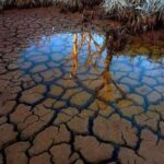 Globally Groundwater is Vanishing From Human Over Exploitation
 How Close Are We To A One-And-Done Vaccine For COVID-19 And Other Viruses?
 Investing In Space Ventures Is Hot Right Now


