
November 26, 2013 – Disaster response teams have been using crowdsourcing as a way to identify those areas most in need of aid after Typhoon Haiyan roared through the Philippines on November 8.
The crowdsourcing involved people from all around the word who viewed satellite images from space and provided relief agencies with their knowledge of the changes that had occurred on the ground after the storm passed.
Officials from the United Nations Office for the Coordination of Humanitarian Affairs (OCHA) coordinated the effort to get volunteers to help with the aid relief. Doctors Without Borders received updated maps generated by over 1,000 OpenStreetMap volunteers in 82 countries. They identified hospital locations, which buildings were intact and which were damaged, blocked roads, and other key infrastructure.
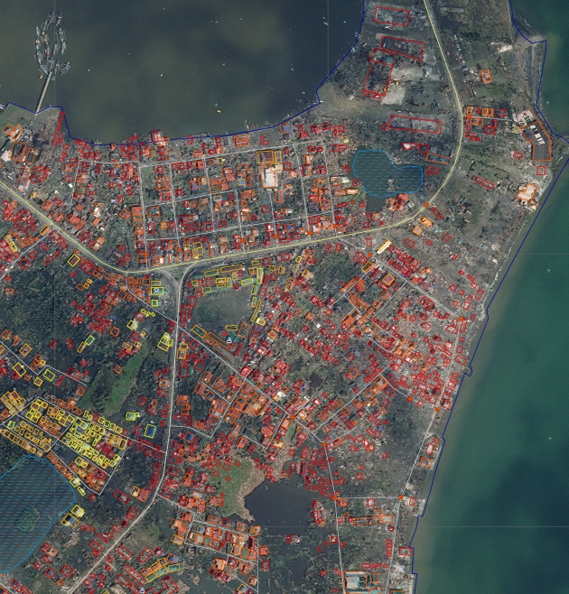
More than one million Tweets and text messages were tapped and then mapped using MicroMappers, applications designed for disaster response. In Tacloban, the city that bore a direct assault from Haiyan’s storm surge, 58% of the built up areas were destroyed or damaged. In the image below you can see orange, red and yellow colour-keyed buildings. The orange represent seriously damaged structures. The red indicates buildings that were completely destroyed. The yellow are buildings largely intact.
Related Posts
 Safe and Efficient Charging Is Needed to Support the EV and Carbon Transition
 Why Am I Left-Handed? Blame Tubulin Proteins for This Asymmetric Brain Twist
 Dark Matter and the Cosmic Web in the News
 The Saga of Honeybee Colony Collapse is Being Questioned
 Hydrogen From Ammonia or Ammonia Itself May Power Our Future
 Can Artificial Photosynthesis Be The Key to Mitigating Climate Change?
 When You Need Portable Energy Storage: A Bluetti EB3A Could Be Your Answer
 Transforming Coffee’s Future With Bioreactors And Cell Power


