April 19, 2016 – This year remains second lowest on record for sea ice coverage in Canada’s Arctic Archipelago. Extraordinary weather anomalies over the 2015-16 winter saw a higher than normal temperatures in November, a lower December and a “crazy-warm” January followed by an above average February.
Ice mass records show the lowest increase for a January in the last decade. Normal ice volume growth associated with winter was lowest on record as well. The likely result will be the smallest sea ice pack ever recorded by the end of this summer.
At some Arctic Ocean sites the ice-free season has increased by more than 30 days over the last three decades with climatologists expecting this trend to continue to accelerate with loss of summer ice cover by mid-century.
The news is “good” if you are thinking of taking a cruise through the Canadian Arctic this summer. Last month operators of a luxury cruise ship, Crystal Serenity, announced August plans for a Northwest Passage cruise starting from Seward, Alaska and ending in New York City. The 32-day voyage would give 1,700 passengers and crew the opportunity to experience something that has been rare until recently, an unencumbered sail through the Canadian Northwest Passage.
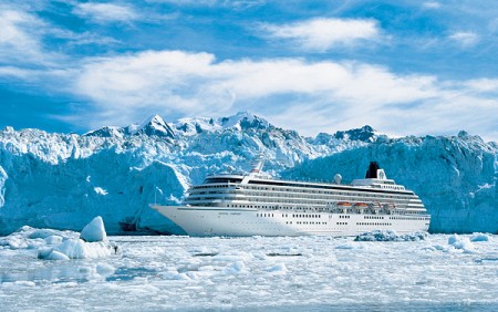
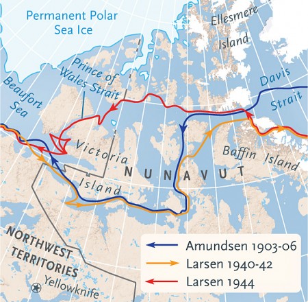
Arctic cruises are becoming more common these days with 17 ships going through the passage in 2015. But most of these vessels were much smaller. The Crystal Serenity, already sold out, will be the first 14-deck luxury liner to transit the exact route first navigated by Roald Amundsen at the beginning of the 20th century. When Amundsen navigated the Passage he and his crew wintered for two years because back then it was ice bound and impassable the majority of the year. But no longer. Now the Passage remains open from mid-summer through mid-fall.
When the Crystal Serenity embarks on its cruise it will be escorted by an icebreaker and two helicopters. In its traverse the ship will make stops at Ulukhaktok and Cambridge Bay on Victoria Island, and Pond Inlet on Baffin Island. Cambridge Bay and Pond Inlet, the two largest communities have fewer than 1,600 residents, 100 less than the passengers and crew on the ship.
So what kind of impact will a ship and its population have on these ports of call? In one article appearing in The Guardian, the author describes it as “a new Titanic,” a catastrophe waiting to happen. How will isolated northern communities manage their own logistics and supply needs while catering to more visitors than they have ever seen? And what happens in the event of an accident or a bunker fuel spill?
The owners of the Crystal Serenity consider this maiden voyage to be the first of many. They intend to have two ships traversing the Passage in 2017. And where these cruise ships go other marine traffic is bound to follow.
But even more impactful than the opening of marine traffic in the Arctic is the change that melting sea ice is making to the physical characteristics of the ocean. Open water means more waves, more storm surges, and greater impact on coastlines. In a report entitled, Canada’s Marine Coasts in a Changing Climate, published by Natural Resources Canada, it describes how the decrease in sea ice is leading to increased coastal erosion. It further states that sea ice has been the defining feature of the Arctic coastline and has dictated the lifestyle and economic climate of the cultures that live along its shores. It goes on to describe how warming is disrupting that way of life and the ecosystems and fragile natural and human infrastructure. As warming increases species migrating north are impacting native flora and fauna. Rising sea levels are inundating coastal communities.
Of course some see benefits in all of this “bad” news. In the Natural Resources report you read comments like “reduced sea ice and deeper waters in many harbours present potential opportunities for shipping.” The corollary to this is “rising sea levels will threaten the viability of some low-lying communities (e.g., Tuktoyaktuk, NT) and increase the risk of flooding and inundation of others.”
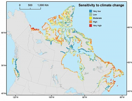
The map below is built from an extensive database called CANCOAST. It projects sea level changes to 2050 taking into consideration a large number of data points including tidal ranges, wave heights and sea ice concentrations. Note the areas marked in yellow, orange and red. These are the ones most sensitive to climate change and the vast majority lie along the northern Arctic coast and within the Arctic Archipelago.
And what about oil exploration and mining development? The temptation presented by an ice-free Arctic Ocean has brought oil and natural gas rigs to this part of the world. Depressed oil prices and a fossil fuel energy glut may be one of the only inhibitors to seeing a major effort by companies to drill. When you consider the recent Royal Dutch Shell accident in which its Arctic drilling rig became incapacitated and had to be abandoned, one can only imagine the potential harm that may come from exploration of this type in the future.
Related articles across the web


Related Posts
 Why Do Conservatives Reject Market-Driven Carbon Emission Pricing?
 Hydrogen From Ammonia or Ammonia Itself May Power Our Future
 Will We Soon Have a Cholesterol Vaccine?
 Weaponized Mosquitoes Are Being Deployed to Reduce Vector-Borne Diseases
 We Use Laundry and Dishwashing Pods – Are They an Environmental Hazard?
 As the Permafrost Melts New Potential Health Threats Emerge
 When It Comes To Hunting For Life on Exoplanets Purple May Be The New Green
 U.S. Using A Supercomputer To Help Communities Model Climate Risk


