
June 17, 2017 – If you live on or near the coastline of these three areas in the United States you need to consider your future plans because the combination of subsidence and sea level changes may turn your family home into a swimming pool. Not familiar with the term subsidence? It describes a change to the physical geography of a location that causes it to sink or subside.
The opposite of subsidence is isostatic rebound, a physical phenomenon which causes land to rise. Melting of land ice at the end of the last ice age is today producing a rebound effect in much of the polar regions of North America, Europe and Asia. The level of rise is measured in millimeters per century.
An interesting characteristic of isostatic rebound is the potential opposite effect it can have on other parts of the land mass where it is occurring. For example, if one part of a continent starts to rise does the continental plate compensate by tipping downward elsewhere?
Our children’s children may see isostatic rebound in action should Greenland ice continue to melt significantly in the next century. The island’s elevation will more than likely begin to rise while the water it discharges in the North Atlantic will submerge coastlines.
But I digress from the topic at hand which is to describe three areas of the Continental United States including Alaska that represent great risk to populations living there with discernible impacts likely to happen within the next thirty to fifty years.
So what are these areas?
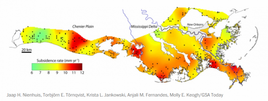
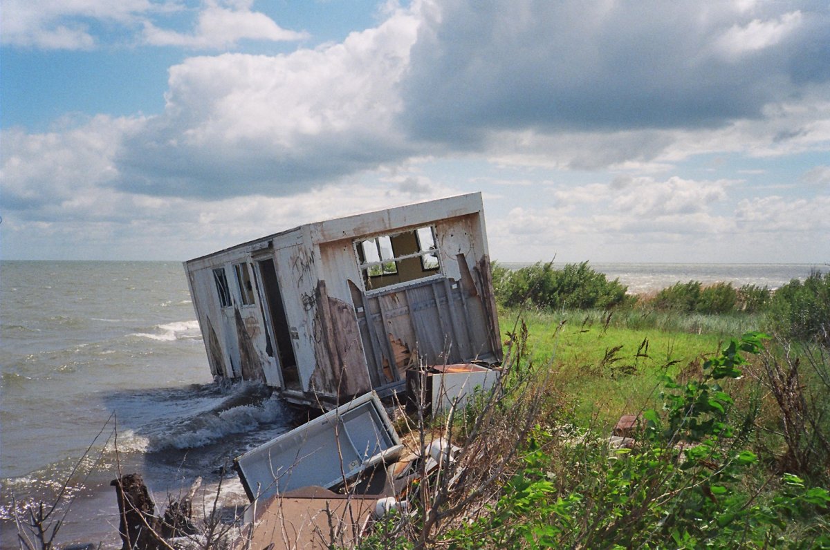
The first is Coastal Louisiana. A research paper published on June 14, 2017 in GSA Today, describes the “catastrophic rates” of loss the state is experiencing. In the past century alone the disappearance of Louisiana wetlands is equivalent to an area the size of the state of Delaware. What’s causing the subsidence? Human intervention on the Mississippi River such as the building of levees for flood control, and the straightening of the shipping channel, that is causing the delta to shrink and that impedes natural sedimentation from the river to restore shorelines. Add to this oil and gas extraction near shore and you have subsidence of the adjacent sea floor. Now combine that with rising sea levels in the Gulf of Mexico and you have the likelihood of dramatic physical changes to much of the coastline as well as implications for the future survival of the city of New Orleans. In the map appearing below, subsidence is indicated in millimeters per year with much of the coastline seeing annual elevation declines of 9 or more millimeters.
The second is Chesapeake Bay which includes the lower Potomac River Basin and Washington, DC. Chesapeake Bay is one of those areas of North America affected negatively by isostatic rebound in more northerly reaches of North America. For over 100,000 years ice covered much of the northern part of the United States as far south as the Ohio River Valley and Pennsylvania. The weight lifted 12,000 years ago and ever since Pennsylvania and parts of the Ohio Valley have been rising, tilting the areas to the south and east downward. Chesapeake Bay is the victim of this isostatic rebound and is continuing to subside for what is expected to last many centuries into the future. Combine the 1.7-millimeter rebound with mean rising sea levels of 1.7 millimeters and the land along the bay’s shoreline is vanishing. This is impacting the Delmarva Peninsula (Lower Maryland, Delaware, and Virginia), Washington, Baltimore, and Hampton Roads, the latter the home of one of the United States’ largest naval bases and air reserve.
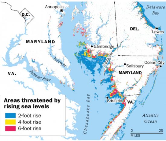
The latest Chesapeake Bay story made national news this week as the saga of disappearing Tangier Island. Located off the Maryland mainland, the island’s 450 permanent residents describe their home as “eroding away.” As largely pro-Trump in voting record, they don’t talk about climate change. Erosion is the operative word. And the rate is significant at over 4 meters (15 feet) of the island vanishing annually. Since 1850, the combination of both subsidence and rising sea levels has shrunk the island by two-thirds. And now sea level rise is accelerating the process making the island uninhabitable by 2040.
But President Trump called the mayor of Tangier to tell him he shouldn’t be concerned, that the island will be around for centuries to come. The President obviously doesn’t believe in isostatic rebound or climate change. For the Islanders, the promise of a $30 million seawall to surround what remains of their disintegrating homeland, was not forthcoming from the President. He’s saving money for the Mexican wall.
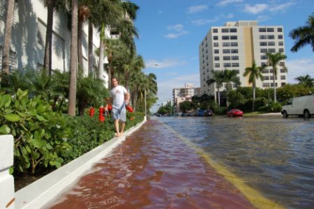
Our third at risk coastline is South Florida. From Maine to the Florida Keys, the sea levels are rising faster than almost anywhere else in the Atlantic Ocean Basin. And in South Florida, sea level rise is combining with a sinking freshwater table which is accompanied by land subsidence. The combination of the three presents a major threat to residents of the peninsula.
Much of South Florida today is a wetland, The Everglades. But human activity has tried to turn the area to agricultural production. In the process throughout the 20th century, the wetland has been drained to remove massive amounts of ground and surface water. The result, declines in elevation in many areas of as much as two meters or more. In fact, from 1967 to 2009, annual subsidence of more than a centimeter (0.55 inches) has been recorded.
This isn’t the downward tilt to a more northerly isostatic rebound as is found in Chesapeake Bay. Rather it is similar to the subsidence of Louisiana’s coast, human derived. And when added to rising sea levels does not bode well for much of Miami and Fort Lauderdale without drastic feats of engineering to save these cities from inundation. Today even on sunny days the streets of Miami experience flooding. These used to be once in awhile events. Now they happen several times per month.
These three at-risk areas are not alone. It is estimated that 13.1 million Americans will be displaced from their homes by the combination of subsidence and rising sea levels by century end. Most live on the Atlantic and Gulf of Mexico coastlines. And although it seems like a long way off, the year 2100 is within two generations’ reach. That means those of you starting to raise a family today may see some of these communities inundated as your children begin families of their own. If you live in Miami or Fort Lauderdale, or Washington, DC, or New Orleans, those who follow two generations from now may not be given the same opportunity to appreciate what was once there.
Related Posts
 An Ultrasound Sticker You Wear Can Monitor Your Health
 Hydrogen From Ammonia or Ammonia Itself May Power Our Future
 Conversations About AI: Three AIs Explain Russia’s Invasion Of Ukraine
 Yesterday Was Solar Eclipse Day And It Didn’t Disappoint
 Wearable Technology and the Advent of Artificial Intelligence
 Autonomous Vehicles, Artificial Intelligence and The Internet of Things
 Should the U.S. Power Grid Move Underground?
 Study Shows Canada and Other Countries Unprepared for Cyberthreats


