
July 28, 2017 – It’s going to take some amazing dieting to reduce the Earth’s bulging tropical zone over the next century and beyond. The official tropics lie between the Tropic of Cancer and Capricorn, both 23.5 degrees latitude in relation to Earth’s Equator. These latitude markers indicate the zenith point for the Sun reached at the beginning of summer in both Earth’s hemispheres. Traditionally, they also are a rough approximation of the demarcation separating tropical and temperate zones on the planet.
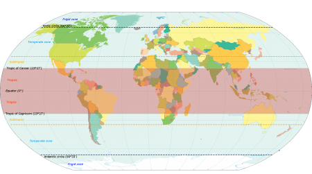
The reality, however, is that the tropics reach up to 30 degrees latitude on both sides of the Equator. In the United States, that means the tropics cut through Florida, Louisiana, and Texas. And elsewhere in the northern half of the planet, North Africa, the Middle East, the Indian subcontinent, Nepal, China, Japan, and Mexico. The 30-degree latitude line, cutting through the Southern Hemisphere, touches South Africa, Australia, Chile, Argentina, and Brazil.
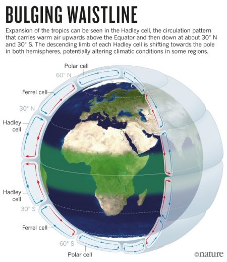
In a February 2017 posted paper in Geographical Research, Stephen Turton presents evidence of poleward expansion “at an alarming rate.” He sees this as having “massive implications for societies, economies, and natural environments.” In his analysis he concludes this expansion of Earth’s tropical waistline is “determined largely by anthropogenic drivers — notably, rises in greenhouse gasses.” Turton goes on to describe the latitudinal shift of climate zones as impacting the temperate regions of the planet severely, but also, within the tropics, producing conditions of such extreme heat to be unprecedented for “hundreds of millions of people.”
Since 1979 the average rate of tropical expansion has been calculated at between 56 and 111 kilometers (35 to 69 miles) per decade. That’s movement of between 0.5 and 1 degree of latitude every 10 years. Taking 30 degrees latitude as the end of the tropics, at the current rate of change, within 80 years, the zone will expand to 38 degrees both north and south. The put this in context, the 38th parallel separates North and South Korea. It runs through the centre of the Mediterranean Sea south of the toe of Italy. In the United States, it means Utah, Colorado, Kansas, Illinois, Indiana, Kentucky, West Virginia, Virginia, and Maryland will be in the tropics. In the Southern Hemisphere, New Zealand will be added to those countries already mentioned above. And in Australia, Melbourne will lie within it.
The anthropogenic drivers of this change are defined as increasing greenhouse gasses, black carbon both in the atmosphere and deposited on glaciers, aerosols, forest fires, tropospheric ozone, and warming oceans. The symptoms include a meandering Jet Stream over North America, Europe, and Siberia, and cloud changes, particularly increases in top height. Another symptom is the movement of dry subtropical climate zones to areas formerly temperate.
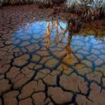
Turton projects “the dry subtropical region will expand by as much as 30 percent by 2100, with massive implications for the management of water resources, agricultural systems, ecosystems, biodiversity, and biosecurity.” He sees the greatest impacts may be on Mediterranean climate zones which experience winter rains and hot dry summers. For countries bordering the Mediterranean Sea, California, South Africa, and Southwestern Australia, drier conditions will impact agricultural production and urban life in these locales.
Temperate biodiversity will feel the change. Ecosystem disruption is likely to follow the shifting tropical zone boundary as it expands. We are witnessing the migration of malaria, Dengue fever, Zika, Lyme and other tropical diseases today along with their hosts as these disease vectors move poleward.
Add to this the decline or extinction of temperate animal and plant species, particularly those incapable of matching the current expansion rate of 5 to 11 kilometers (3.5 to 7 miles) per year. Only areas where expanding tropics meet mountains will species find safe eco-niche havens in isolated elevated islands. But in their isolation, these survivors of our growing tropical waistline will experience new population and evolutionary pressures.
And finally, in areas close to the Equator, our species and the rest of Earth’s life will really feel the heat. Known as the Thermal Equator, the zone that straddles the 0-degree line will be subjected to higher day and nighttime temperatures. The majority of megacities today lie within this growing area. Many are in the Developing World where there is a lack of infrastructure to combat heat and extreme weather.
Extreme weather including prolonged heat waves and droughts, more violent rainstorms, and flooding events, represent what is anticipated in the growing Thermal Equator, an area of the planet where demographers anticipate the greatest increase in our population as the world grows to 10 billion plus by 2050.
Related Posts
 Globally Groundwater is Vanishing From Human Over Exploitation
 Can Planets Exist Without a Star?
 What Is a Weather Whiplash Event?
 New Gene Editing Cas-CLOVER Adds an Alternative to CRISPR/Cas9
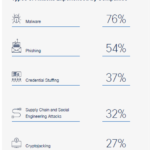 Study Shows Canada and Other Countries Unprepared for Cyberthreats
 Can Kinetic Energy Harvested From Human Activity Help Save The Planet?
 When You Need Portable Energy Storage: A Bluetti EB3A Could Be Your Answer
 Should the U.S. Power Grid Move Underground?


