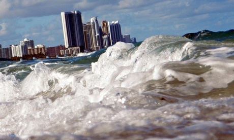
March 5, 2015 – From the perspective of coastal southern Florida it takes little imagination to realize just what is at risk from rising sea levels, a consequence of global warming. The area where my wife, our dog and I are staying lies a little over one meter (3.3 feet) above sea level. Every rainstorm causes roadway flooding in front of our apartment. A storm surge could bury the road under several feet of water and sand. When you add rising sea levels and the sinking of the land in South Florida you have a recipe for a foreseeable disaster.
New York City, a little over 1,600 kilometers (1,000 miles) away also lies along a coastline. It is one of 180 municipalities in the United States that abut an ocean or salt water gulf. The city in the last month released its own version of the United Nations’ Intergovernmental Panel on Climate Change. Called the New York City Panel on Climate Change or NPCC2, it attempts to forecast the future to the end of the century and describes adaptation and mitigation strategies focused on the city’s survival.
What do New York’s experts see in their crystal ball?
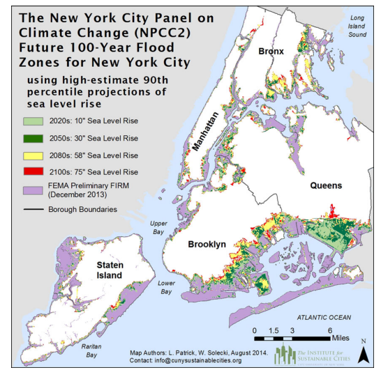
- Rising sea levels and coastal flooding pose the largest risk to the city over the course of the 21st century. Projections for rising sea levels are 28 to 53 centimeters (11 to 21 inches) by the 2050s, 46 centimeters to 1 meter (18 to 39 inches) by the 2080s, and 1.8 meters (6 feet) by 2100. These projected sea level changes are expected to increase the frequency and intensity of coastal flooding, leading to a 10 to 15-fold increase in the frequency of current 100-year coastal floods by the 2080s.
- Mean annual temperature projections for 2050 range from increases between 2.3 and 3.2 degrees Celsius (4.1 to 5.7 Fahrenheit) by the 2050s and 2.9 to 4.9 degrees Celsius (5.3 to 8.8 Fahrenheit) by the 2080s. The frequency of heat waves is projected to triple by the 2080s, and extreme cold events are projected to decrease (which will be somewhat of a relief to New Yorkers who have lived through the last two winter polar vortices).
- Mean annual precipitation is projected to increase between 4 and 11% by the 2050s and 5 to 13% by the 2080s. The frequency of extreme precipitation days will increase by a factor of 1.5 by the 2080s.
New York may be better prepared than most American coastal cities. Hurricane Sandy has been a catalyst for the emergence of new policies which include the hardening of infrastructure, restoration of wetlands and other strategic investments as part of the city’s climate change strategy. With 33.8% of the city at an elevation of less than 6 meters (20 feet), the City for the most part will remain above the rising waters. But much of downtown Manhattan is at risk. The map below gives you a sense of what areas of the five New York boroughs will be most impacted.
Back in 2011 a study looked at the projected impact of climate change on American coastal cities. For those with populations greater than 50,000, 9% of the land lies below 1 meter (39.36 inches) above sea level, and 36% of the land lies below 6 meters (20 feet). Using New York’s projected time lines, and all things being equal in terms of a uniform rise in sea levels, that means one-eleventh of existing city land will be underwater by 2080.
An additional factor to consider. High tide varies from place to place and high tides are always higher than elevation zero. So that means a high tide could easily exceed the 1 meter level making areas above that elevation susceptible to inundation.
The authors of the study point out that the southern tip of Manhattan in New York City has average high tides of 0.9 meters (2.95 feet) while in Seattle high tides reach 2.5 meters (8.2 feet).
The study listed the 20 largest American cities most vulnerable to rising sea levels. The ranking is done by percentage of below 6 meters in elevation. Here they are:
- New Orleans, Louisiana – 99.8%.
- Miami, Florida – 97.8%.
- Virginia Beach, Virginia – 95.4%.
- Jacksonville, Florida – 44.8%.
- Tampa, Florida – 42.3%.
- Sacramento, California – 35.7%.
- Boston, Massachusetts – 34.7%. For more on Boston see Boston’s climate plan.
- New York City, New York – 33.8%. See a previous posting describing New York’s climate plan.
- Long Beach, California – 31.9%.
- Oakland, California – 27.2%.
- Philadelphia, Pennsylvania – 18.2%.
- San Francisco, California – 14.2%.
- Washington, DC – 12.5%.
- Baltimore, Maryland – 11.5%.
- Seattle, Washington – 10.4%.
- San Jose, California – 10.2%.
- Portland, Oregon – 9.7%.
- San Diego, California – 5.1%.
- Houston, Texas – 2.5%.
- Los Angeles, California – 2.4%.
It is no surprise to see New Orleans (remember Hurricane Katrina) topping the list. Nor should it be a surprise to see Miami and other Florida cities in the top 5. All of South Florida is susceptible to rising sea levels, compounded by the land subsiding. A similar phenomena is happening in Chesapeake Bay where Virginia Beach can be found as well as the lower Potomac River and Washington, DC. The combination of climate change induced sea level rise and subsidence is making much of the U.S. eastern seaboard vulnerable.
How are all these American cities coping with the immediate let alone fifty year threat? According to Gary Griggs, Director of the Institute of Marine Sciences, University of California, Santa Cruz, most communities treat the increased frequency of inundations from high tides as “nuisance flooding.” This trivializes the growing threat.
In a January 15th, 2015, article in Scientific American, the author states that most cities lack a plan to tackle rising sea levels. Why? According to Klaus Jacob, a research scientist at Columbia University who consults with New York’s Metropolitan Transit Authority on the issue of climate change and rising sea levels, why cities and other governments are not pursuing policies and projects, other than in a haphazard manner, is they lack the political will to deal with it. One reason is the amount of money involved to create flood management infrastructure needed. Jacob estimates that cost this century to be over a trillion dollars, but warns, “if we don’t do anything, it’s multiple trillions of dollars.”
Related articles across the web


Related Posts
 New NASA Report Shows Sea Level Rise Is Accelerating: Causes and Consequences
 The Nuclear Arms Race Never Ended
 Decarbonization Conversations: Using Seaweed to Store Carbon on The Ocean Floor
 It’s the Middle of February and I Just Came in From Sitting on My Balcony
 Safe and Efficient Charging Is Needed to Support the EV and Carbon Transition
 The Saga of Honeybee Colony Collapse is Being Questioned
 We Live in the Age of Popcorn Brain and Smartphone Addiction
 Public, Court Interventions and Climate Change


[…] 180 U.S. cities are threatened by rising sea levels and most have no plans in place to deal with it. Ignoring it will cost trillions. […]