
When I sat down for a chat with Mario Paniccia, the CEO of ANELLO Photonics, on August 6, 2025, to discuss a new navigation technology called SiPhOGTM, an optical gyroscope, I said, “What you have invented is life imitating art.” He asked me, “How so?”
I talked about several episodes of the popular network comedy, “The Big Bang,” where the Caltech friends work on a gyroscope using quantum states and dynamics for navigation. When they apply for a patent, the U.S. Department of Defence comes calling.
Mario laughed and said that one of his clients had told him about it. Although SiPhOG is not using quantum states for positioning, it is achieving the same purpose, providing highly accurate navigation. SiPhOG stands for Silicon Photonic Optical Gyroscope. When this tiny sensor is put into a system, it can work to complement current global positioning system (GPS) technology or operate as a standalone solution, filling the navigation gap.
Today, GPS provides navigation assistance worldwide using a constellation of satellites and ground stations. Conceived by the U.S. Department of Defense in 1973 and fully operational by 1993, GPS uses 31 satellites, each containing an atomic clock and a transmitter that communicates with ground stations and receivers. The ground stations monitor the health of the system, correct for drift, atmospheric signal delays and changes to the satellites’ orbits.
Cars, ships, aircraft and smartphones, today, have GPS receivers to determine their locations within 30 to 500 centimetres (0.98 to 16 feet) if military grade or 7 metres (23 feet) for civilian use. Positioning requires at least four of the 31 satellites. They produce a 3-dimensional reading for the receiver’s location and determine latitude, longitude and altitude.
GPS has replaced paper maps and route planners. Its success has led Russia to copy it with GLONASS, the European Union with Galileo, China with BeiDou, India with NavIC, and Japan with QZSS. But satellite-based navigational aids don’t work everywhere. Why not? Satellite-based navigation requires a direct line of sight to the open sky. When is that not possible? It is hard to find open sky in cities with tall buildings. GPS won’t work inside buildings and underground garages, or tunnels. It cannot find hikers in dense canopied forests. Nor can it track a robot tractor spraying insecticides as it rides through a leafy orchard. Forget trying to use GPS on submarines and submersibles underwater.
This is where SiPhOG excels. Mario calls it the first new gyroscope technology to come on the market in the last two decades. Its uses include the military, aerospace, land and sea vehicles, robots, drones and more.
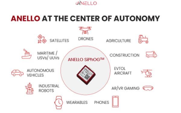
A single SiPhOG product is less than 25 millimetres square (see the picture at the top of this article). The integrated photonic chip inside the SiPhOG is no more than 2 by 5 millimetres (0.0155 square inches). It has low energy requirements, a mere 850 milliwatts, nearly one-tenth the power requirement of older optical gyroscopes like FOGs (fibre optic gyroscopes).
Its bias is 0.5 degrees per hour. It can be boxed in devices combined with accelerometers and other sensors, as well as AI algorithms and sensor fusion (the process of combining data from multiple sensors to produce a more reliable and accurate understanding of the environment) for enhanced navigation solutions and applications. When used in a navigation system for real-time positioning, it achieves 99.9% accurate navigation in tests involving distances of 100 kilometres (approximately 62 miles) for land vehicles.
Older optical gyroscopes like FOGs (fibre optic gyroscopes) cannot be used for mass market solutions because of their size, energy demands, complexity and cost. MEMS (micro electromechanical systems, while small and low power, cannot be used for accurate navigation because the technology is less accurate and very sensitive to temperature, vibration and EMI (electrical mechanical interference).
Mario spent 22 years at Intel before founding ANELLO. His area of expertise is silicon photonics, which he brought to the company. He and his team took four years to build the first SiPhOG. How does it work? Within the tiny photonic chip, it takes in a broadband laser source and splits it into two beams. The two beams are then sent into a coil, where they propagate in different directions. As the coil rotates, the light travelling in the same direction as the rotation experiences a slightly shorter path than the light travelling the opposite way. This tiny phase shift is measured using an integrated photodetector and a specially designed low-noise electronics detection system. By measuring the phase shift and knowing the length and diameter of the coil, one can calculate the rotation rate or bias drift. With no moving parts and being insensitive to temperature shifts, vibrations, and electromagnetic interference, SiPhOG produces precise inertial navigation that delivers accuracy and reliability with or without GPS present.
The ANELLO AI-powered sensor fusion engine continuously evaluates GPS signals in real time, and when that signal degrades, an algorithm shifts navigation reliance to the SiPhOG. If a drone relying on GPS gets jammed or spoofed, with SiPhOG onboard, it can automatically switch to its inertial navigation with complete awareness of its surroundings. Needless to say, SiPhOG is truly a disruptive technology which should have an enormous impact for many different uses.
Mario shared with me several use cases for ANELLO SiPhOG-based technology:
- Using it to deliver precision agriculture, requiring accurate positioning and guidance for tractors.
- Using it on land vehicles in GPS-denied environments for up to 60 minutes operating at speeds of 50, 90 and 120 kilometres (30, 50 and 75 miles) per hour as demonstrated at NAVfest, the annual United States Air Force event at White Sands Missile Range, New Mexico, and the Dugway Proving Ground for the U.S. Army in Utah.
- Using it with aerial drones to demonstrate the technology’s resistance to jamming, spoofing or intermittent loss of GPS.
- Using ANELLO-designed robust navigation solutions incorporating SiPhOG chips for unmanned surface and underwater vessels in demonstrations for oceanographic research and larger craft for the U.S. Navy.
As I spoke to Mario, I was thinking about how SiPhOG could revolutionize how the blind navigate. I had written a 2014 posting describing a smartphone navigation system that blind people could use in buildings. It seemed novel at the time, but was far more complex than what I can see Mario’s technology doing to create “a blind navigation system app,” running on a smartphone or smartwatch.
Who knows, maybe in mentioning this, and with future integration making SiPhOG even smaller, ANELLO will create an application for this amazing technology that could give the blind second sight, not visionary, but an ability to navigate the world without seeing eyes, just as they are doing today without GPS.