
April 8, 2019 – In the latest musings from Peter Diamandis with additional content from me, I describe how technological innovation using AI, robotics, sensors, and high-speed networks is transforming how to respond to, and even prevent disasters. In his email blast, Diamandis cites the cost of natural disasters around the world between 2005 and 2014 at 700,000 lives lost and $1.4 trillion USD in damages. He also notes that the past 50 years have witnessed a 500% growth in natural disasters which obligates us to address this growing problem which will be further exacerbated by climate change extreme weather events. The solution, a wide range of emerging and powerful technologies that include artificial intelligence (AI), robots, and the connectivity of the Internet.
Diamandis selects three technologies that he believes will have the greatest impact on dealing with the aftermath of or the prevention of disasters. These include:
- AI, predictive mapping, and the power of crowdsourcing
- Next-generation robotics and swarm solutions
- Aerial drones and immediate relief supply
Artificial Intelligence and Predictive Mapping
When it comes to immediate and high-precision emergency response, data is gold. The meteoric rise of space-based networks, stratosphere-hovering balloons, and 5G telecommunications infrastructure is connecting every last individual on our planet. Aside from democratizing the world’s information, this upsurge in connectivity is granting all of us the ability to broadcast detailed geo-tagged data, which is particularly valuable in the face of natural disasters. Armed with the power of data broadcasting and crowdsourcing, disaster victims can now play an important role in emergency response, turning one-way blind rescue operations into a two-way dialogue, connecting the crowd to smart response systems. With the skyrocketing abundance of collected data comes a new paradigm, one in which we no longer have few answers, but rather now can ask the questions needed to ensure we can address the disaster in near real-time.
In the case of emergency response, we can strategically map an almost endless amount of incoming data points. We can begin to predict the dynamics of a flood and identify a tsunami’s most vulnerable targets even before it strikes. And we can trigger automatic aid using surveillance drones which can immediately alert volunteers to take action. Already, a number of organizations are leveraging AI, crowdsourced intelligence, and cutting edge visualization to improve crisis response and speed up relief efforts.
One of these is One Concern. Conceived by victim survivors of past catastrophes and geologists studying volcanoes, this organization leverages AI through analytical disaster assessment to calculate damage estimates. So far One Concern is partnering with a number of California cities including Los Angeles and San Francisco to create unique ‘digital fingerprints’ for every element in an urban area. Their AI platform creates robust models which then help to monitor site-specific impacts from climate change, earthquakes, and other natural disaster events. The collected data when combined with information from these cities including their histories of previous disasters, is then used to predict future damage providing recommendations on structural improvements for prevention and mitigation. Since its inception four years ago One Concern has grown in its ability to make predictions with 85% accuracy in under 15 minutes.
Besides handling natural disasters, there are other uses for crowdsourced intelligence for mapping potential crises. The story of Ushahidi is a case in point.
Ushahidi is the Swahili word for “testimony.” The technology came from a local blogger’s idea to collect reports of violence in Kenya in the 2008 post-election period and map their locations. He sent out a request to techies to create a mashup of where violent and destructive episodes were being reported. Within days, four techies built a platform to crowdsource first-hand reports through short message services (SMS), collecting over 40,000 verified reports and sending back alerts to locals on the ground and viewers around the world.
Ushahidi today is being used in more than 150 countries, with over 100,000 deployments impacting 20 million people. Its open-source crisis-mapping software is accessible to anyone, mining millions of tweets, hundreds of thousands of news articles, and geo-tagged, time-stamped data from countless sources all posted to the Cloud.
Aggregating one of the longest-running crisis maps to date, Ushahidi’s Syria Tracker has proved invaluable in crowdsourcing witness reports, providing real-time geographic visualizations of all verified data, and enabling civilians to report missing people, civilian casualties, disease outbreaks, and relief supply needs all while avoiding the government-controlled cellular network.
What’s in the Future?
As mobile connectivity and abundant sensors converge with AI-mined crowd intelligence, real-time awareness will only multiply in speed and scale. Within the next 10 years, spatial web technology may even let us tap into mesh networks. While traditional networks rely on wired access points and wireless hotspots, the spatial web connects entire cities using hundreds of dispersed nodes that communicate with each other and share network connections non-hierarchically, which means that individual mobile users can establish a local mesh network together using nothing but the computing power of their handheld devices.
If taken further, a local population of strangers can collectively broadcast countless 360-degree feeds across a mesh network. So imagine a scenario in which armed attacks break out across disjointed urban districts. Eye-witnesses and at-risk civilians will be able to broadcast an aggregate of 360-degree videos, all fed through photogrammetric AIs that will build a live hologram in real time to create complete information for first responders. The technology could help a community facing failing infrastructure from a hurricane’s landfall providing a collective live feed of verifiable data in real-time to inform first responders about specific relief needs.
With all the right technology pieces in place, first responders will be able to use drones for automated deliveries. Imagine crowdsourced intelligence, cross-referenced with sensor data and verified algorithmically, along with AI to determine the specific needs and degree of urgency with precision coordinates. Within minutes swarm robots can rush to collect requisite supplies, equip size-appropriate drones and provide rapid-fire delivery.
But wait, there are other breakthroughs on the horizon with AI-geared robots paving the way in emergency response for some of today’s most dangerous environments. These include autonomous robots and swarm solutions.
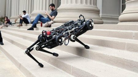
As hardware advancements converge with AI we will see the emergence of fully autonomous disaster relief robotic responders. A prototype is the Cheetah III, a product of MIT’s Biomimetic Robotics Lab. Cheetah III is capable of running at a 6.4 meters (21 feet) per second pace, can leap heights of 60 centimeters (almost 2 feet), and has sophisticated collision and obstacle avoidance capability. Robots like this may form the first line of defense in disaster responses to earthquakes for search-and-rescue missions, or for surveillance in high-risk radiation zones. Future plans for the robot include payload carrying capability, enhanced range of motion, and increased dexterity. Stated Biomimetic Robotics Lab Director, Associate Professor Sangbae Kim, “the short-term goal will be sending the robot where we don’t want to send humans at all.”
Joining the Cheetah III are a number of other robots designed for working in hazardous zones. In February Japan’s Tokyo Electric Power Company inserted a robot into the damaged Fukushima Nuclear Reactor to retrieve a number of samples of radioactive fuel for analysis and cleanup planning on the site. This robot was guided by human operators and was able to operate in an environment where no one could safely go.
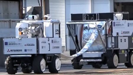
Also in Japan, Mitsubishi Heavy Industries (MHi) has built a firefighting robot called the Water Cannon Bot designed to put out fires at sites considered too dangerous for human entry. It can deliver foam or water at a rate of 4,000 liters (over a 1,000 gallons) per minute and at pressures of 1 Megapascal (145 PSI). The robot can be accompanied by a companion Hose Extension Bot extending the firefighting range by 300 meters (almost 1,000 feet). Imagine using this kind of robot to fight wildfires when combined with predictive AI forest fire mapping and autonomous hauling vehicles, and you have a solution for what is becoming a growing problem as climate change dries out many forest areas. Deployment in anticipation of wildfire would mean the avoidance of population displacement, unnecessary deaths, and significant damage to natural environments.
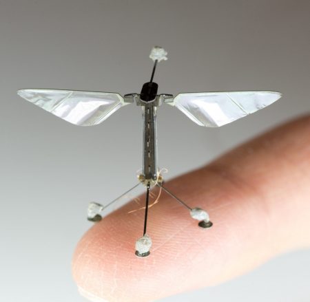
There are RoboBees developed at the Wyss Institute, Harvard University. These autonomous flying micro-robots have the potential to be used for crop pollination, search and rescue missions, surveillance, and high-resolution weather, climate, and environmental monitoring. They feature self-directed flight and swarm behaviour, that is the RoboBees can work together as a single unit for co-ordinated surveillance operations.
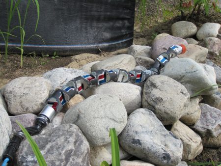
There is Snakebot, developed at Carnegie Mellon University, and designed to navigate in environments completely inaccessible to human responders. Driven by AI, a Snakebot can maneuver through densely packed rubble to find survivors and has onboard cameras and microphones to aid in communication.
Advancements in drone technology will revolutionize disaster response whether to natural phenomena or wars. Drones provide high-resolution imagery for real-time mapping and damage assessment and are already outperforming ground-based rescue teams in locating isolated survivors of a catastrophe. In the aftermath of Hurricane Harvey, a team led by Texas A&M Computer Science Robin Murphy flew 119 drone missions over Houston, to monitor levee infrastructure and identify people left behind by rescue teams.
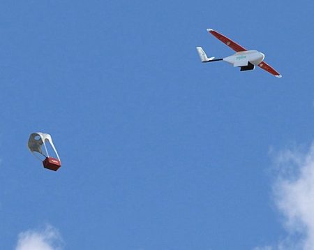
But drones are capable of much more than surveillance. At the University of Science and Technology of China, engineers have built a first responder temporary mobile wireless broadband network facilitated by airborne drones. And drones are being used to supply remote areas of the planet with lifesaving medicines. One of these is Zipline, a drone delivery system operating in Rwanda and Tanzania that is delivering vaccines, HIV medications, blood products, and intravenous supplies to 11 million living in remote locations. Zipline, a California-based company, has far outpaced any ground-based supply transport, in many instances providing lifesaving biomedical products in under an hour.
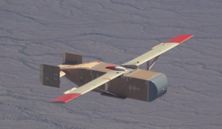
Larger capacity aerial drones are being developed for the U.S. Military. Logistic Gliders is using plywood-constructed gliders costing only a few hundred dollars to provide the U.S. Marine Corps with aerial resupply capacity at 816 kilograms (1,800 pounds) per flight. Flying at speeds of up to 250 kilometers (135 nautical miles) per hour, and a 140 kilometer (80 miles) range, these drones can be released from an aircraft or helicopter and are disposable. They can operate autonomously or be guided remotely.
Diamandis’ Concluding Thoughts
Perhaps one of the most consequential and impactful applications of converging technologies is their transformation of disaster relief methods. While AI-driven intelligence platforms can crowdsource firsthand experiential data from those on the ground, mobile connectivity and drone-supplied networks are granting newfound narrative power to those placed in need because of natural or human-caused disasters. It is this rise of robotic responders, swarm technology and aerial drones that are giving us unprecedented response capacity to catastrophes. Empowered by these new tools, how much can we improve humanity’s overall plight when everyone has similar access to relief supplies and immediate resources in times of disaster?