
When we talk about climate change the conversation usually involves discussions about a warming atmosphere, the shrinking of polar sea ice in the Arctic, and whacky weather. But what if I told you that an even greater threat trending from climate change is the one that will impact some of the longest and most important river systems in the world. Which ones are they?
Asian Rivers at Risk
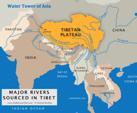
The map above shows how Asia’s rivers rely on Himalayan glaciers to provide much of the water that feeds China, India, Vietnam, Laos, Thailand, Burma, Nepal, Bhutan and Pakistan. These glaciers are twenty times the size of those found in the European Alps and feed the Ganges, Indus, Mekong, Yangtze, Huang He (Yellow), Brahmaputra (a major branch of the Ganges), Irrawaddy and Salween rivers which provide drinking water and irrigation for 1.5 billion people in nine countries.
Before we look at the river basins themselves it is important to understand what exactly scientists are observing in the Himalayas and the Tibetan Plateau. The eastern and central parts of this area of the world are seeing accelerated melting affecting water sources for rivers draining from that area. While the western areas remain unchanged or are seeing glacier growth so that rivers relying on these sources are unaffected.
This variability in the Himalayan glaciers is attributed to the difference in mean altitudes between the western and eastern parts of the mountain and plateau area with the east experiencing greater heating because of terrain features and higher elevation. Other potential factors include atmospheric pollution drifting in from the burning of forests in India and Indonesia, and from desert dust and increased desertification along the edge of the Gobi.
For those areas that continue to rely on the annual monsoon precipitation the melting of alpine glaciers and the snow pack will have less impact. But the monsoons have a lesser affect on the upper reaches of these rivers where headwaters originate. That means if glacial melt increases or decreases it may impact populations in the upper courses more than the monsoon-fed downstream areas. But monsoons are seasonal and from time to time they don’t come and these areas experience drought. It is during these times that the glaciers become the significant provider of continuous river flow. Needless to say if climate change models are right, and most scientists believe very strongly that they are, Himalayan glaciers will play a significant and growing part in the increasing water crisis in this part of the world.
So let’s look at these glacier fed rivers and the enormous importance each plays for the people, animals and plants that live along their banks.
Ganges River
Also known at the Ganga stretches 2,525 kilometers (over 1,500 miles). The main river originates from the melt-water of the Gangotri Glacier in the western Himalayas and flows south and east through an enormous flood plain to its delta on the Bay of Bengal. In Bangladesh the river is joined by its main tributary, the Brahmaputra. The Ganges crosses much of Northern India and Bangladesh. A number of its lesser branches originate in land-bound Nepal.
The Ganges River Basin serves as the agricultural heartland of both India and Bangladesh and the most heavily populated river basin in the world. The river has been dammed for generating hydroelectricity. Much of it is subject to seasonal monsoons with river levels fluctuating dramatically. Water is drawn off for irrigation as well. It is a water source for cities that lie along its course. Industries draw from it. And it is sacred to Hindus.
Today the river faces serious challenges from water overuse with some areas running dry at times. So what will happen should the glaciers of the Western Himalayas experience intensive melting? The Ganges, already running dry in many places would simply cease to exist for periods of time. For the 655 million who depend on it this represents an impending catastrophe.
Indus River
Almost 40% of the water that flows in the Indus River comes from the glaciers of the Tibetan Plateau making it far more vulnerable to any changes in the rate of Himalayan melting. Stretching 2,900 kilometers (1,800 miles) it is Pakistan’s major source of freshwater for urban and agricultural use and a lifeline for the 300 million who live on its banks or near it.
Much of the country through which the Indus flows is extremely arid and other than seasonal monsoons gets little precipitation. This makes it an important source of irrigation and even more susceptible to climate change. The history of the river valley shows just how much small variations in precipitation can exact an enormous toll on people dependent on the river with evidence of an earlier civilization succumbing to past climate events.
Mekong River
Made famous to much of us here in North America because of the Vietnam War, this extraordinary river stretches 4,350 kilometers (2,700 miles) from its origins in the Eastern Himalayas to its delta at the southernmost tip of Vietnam. In China it is known as the Lancang. It contains the second largest freshwater fishery in the world with fish representing the largest protein contributor to the 60 million who live along the river’s banks and tributaries.
The Mekong crosses through four countries (China, Laos, Cambodia and Vietnam) and it is the cooperation of these countries or lack of it that represents a significant threat to the future health of the river basin in the 21st century. China is building numerous dams in the upper Mekong and Laos plans to make similar investments. The dams fulfill the demand for hydroelectricity. The dams already built are impacting river levels downstream significantly. If more (all in the planning stage) get constructed the lower Mekong may run dry. Now add to this climate change with altered seasonal rainfall and rising temperatures in the highland plateaus of the Himalayas affecting glaciation, and the river may encounter even greater fluctuations.
Yangtze River
The third longest river in the world stretching 6,418 kilometers (3,988 miles), the Yangtze is the heart and soul of the Middle Kingdom. It rises from the glaciers of the Tibetan plateau with its basin covering 20% of China. One-third of China population, close to 450 million, live on or near its banks. But increasing melting of the glaciers that feed the Yangtze is threatening the river because unlike the Indus or Ganges, there is no seasonal monsoon to make up the shortfall.
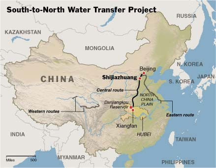
Another Yangtze problem is human water use along the river with much of the flow being taken up by agriculture and industrial use. Today the discharge of raw sewage and industrial pollutants is threatening fish farms and compromising drinking water. Add to this changes in the river flow created by the Three Gorges Dam and the engineering of a South-to-North Water transfer project to replenish the Huang He River to the north and you have a serious water crisis on your hands.
Huang He (Yellow) River
China’s second river and the second longest in Asia is as central to the rise of Chinese civilization as the Yangtze is central to the country. Known as the Huang He or Yellow it is 5,464 kilometers (3,395 miles) long and originates to the north of the Yangtze in the Qinghai-Tibetan plateau. It has always been a temperamental river with major floods throughout its history. These have been some of the worst human disasters ever recorded. Some of the floods originate from collapsed ice dams formed at the river’s glacial source. These ice dams and their breakup continue to be a problem even today with the Chinese government occasionally bombing the ice buildup before it becomes dangerous.
It is this river of all those in this part of Asia that is most susceptible to the environmental impact of global warming and climate change. Since 1966 the glaciers that feed the river have shrunk by 17%. The melting is 10 times the average rate seen over the last 300 years. The cause is rising temperatures and growing deserts as the permafrost melts and the ground dries up. Scientists estimate that overall land degradation in the Huang He source has reached 34.4%.
With water levels in decline, China is embarking on a massive water diversion scheme called the South-to-North Water Transfer Project.
Brahmaputra River
Measuring 2,900 kilometers (1,790 miles), the Brahmaputra originates in the Angsi Glacier of the Western Himalayas. Of all the rivers described here it is the least developed by those who live on its banks. The river crosses the Tibetan Plateau in China before making a dramatic turn into India and finally joining the Ganges near its mouth in Bangladesh. Tributaries of the Brahmaputra flow from Bhutan as well. So all in all the river basin serves four countries.
The population that lives along its banks or nearby numbers well over 30 million. The area is seismically unstable and the river is prone to mudslides along its steep slopes which create temporary dams and flash floods. Yet China is in the process of building a dams in the upper reaches for both flood control and power generation.
Like the Ganges, the Brahmaputra gets its source water from glacial melt but as the river turns into India and Bangladesh also receives a significant amount from the monsoon. Both these water sources may be affected by rising atmospheric temperatures which inevitably will accelerate the melt (although not seen yet in the Western Himalayas) and create variability in the seasonal monsoon (already happening).
Irrawaddy River
At 2,170 kilometers (1,340 miles) this river is the largest in Myanmar (Burma). Most of the 47 million in the country live on or near the Irrawaddy. Its tributaries flow from the eastern margins of the Tibetan plateau and although not directly fed by glaciers originates high in the same mountains as the other rivers we have described here.
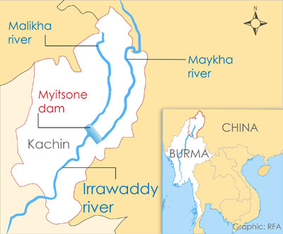
China, Myanmar’s closest economic partner, is in the process of building seven hydroelectric dams along the river and its tributaries. The largest of these, the Myitsone, is an ecological disaster compromising 47 villages and destroying spawning habitats for native fishes. And that doesn’t take into consideration the downstream consequences with diminished flow and impacts to the river delta, a principal growing area for the country.
How will the Irrawaddy deal with the effects of climate change? Because the water source is the Tibetan plateau the river may see a significant drop in flow as glacial sources dry up. In addition changes to vegetation because of altered precipitation patterns and deforestation caused by massive over cutting of Myanmar’s teak forests, river water levels will become far less predictable. Now add the human engineered problem of dams like Myitsone and you create additional uncertainty for the future of the river. Weather variability in the seasonal monsoon could lead to unprecedented droughts which will drastically reduce the dams’ capacity to generate electricity.
Salween River
This river stretches 2,400 kilometers (1,480 miles) from the Tibetan plateau inside China through Myanmar to the Andaman Sea. It is home to over 7 million and is Asia’s last free flowing river.
The basin is narrow like its neighbour the Irrawaddy, and also, like its neighbour is being turned into a giant water diversion project by the Chinese who are in the process of planning to build 5 dams on its upper course. The dams will displace human populations, flood agriculturally productive land, and impact fish stocks. Its downstream impact within Myanmar will be a lowered water table, decreased siltation and fertility in irrigated fields, and falling river levels which will impede navigation.
Now none of these are consequences of climate change. But add that to the mix with decreased river capacity as the glaciers that feed it melt and dry up, and changes to seasonal monsoon patterns resulting from rising atmospheric temperatures and you are cooking up an even bigger disaster.
Related Posts
 Decarbonization Conversations: Using Seaweed to Store Carbon on The Ocean Floor
 How The Rise Of AI Is Shaping The Future Of Business
 Fusion Reaction Energy Yields and Promises Continue to Grow
 Robots in the News: From Tesla Optimus to BMW Figure and More
 XPrize Launches Desalination $119 Million, 5-Year Competition
 What is Bimodal Neuromodulation And Can It Help Treat Tinnitus?
 Another Potential Battery Breakthrough That Uses A Water Electrolyte
 Adjusting Time as the Polar Ice Caps Melt Causing Earth Spin Rate to Change


Good information, well written.
Where’s part 2?
Thanks for pointing out that I never wrote the Part 2 which was going to focus on the Siberian watershed. I need to address that in the near future
The title is a misnomer. Instead of: Climate Change and Its Impact on our World`s Major Rivers it should read: man-made dams and its impact on our world`s major rivers.
[…] Changes to alpine glaciers in such places as the Himalayas, Andes, Alps and Rocky Mountains which would affect downstream rivers (The Himalayas provide much of the source water for China and the Indian subcontinent, the two most p…). […]