
June 11, 2014 – Why do I keep writing about climate change? Because I’m worried that the majority of us don’t get it. So here is different perspective. Think about tourism and how climate change can alter your personal plans in the near future. Extreme weather events, rising sea levels, prolonged drought, searing heat, all could play havoc with those traditional destinations for vacationing and sightseeing.
Let’s look at the United States in the next three decades. What destinations will you not be going to in the future because they may no longer be there?
1. Southern Florida and the Everglades – The vacation land of much of eastern North America is becoming and very much will be the first U.S. casualty of climate change. This is not just a question of rising sea levels. The map below has three prominent features: land elevations, location of the predominant aquifer and current mangrove coastal wetlands. Extreme weather events causing storm surges will endanger the beaches off the North Atlantic. There are no mangrove wetlands to assist in protecting shorelines from massive erosion. And beyond those shores stand much of Florida’s prime vacation real estate at elevations under 1.5 meters (5 feet) in areas to the south of Miami. Miami Beach and the barrier keys are all at great risk. But along with the rise in sea levels and the damage of storm surges comes the salt water invasion of the Biscayne Aquifer impacting freshwater resources critical for Florida’s southern cities. Note that Key West may disappear as a destination since it too lies below 1.5 meters elevation.
At current rates of sea level rise in 2014, approximately 3 millimeters (0.118 inches) per year, that translates to a little over one inch per decade. So an increase of one foot is still over a century away. That’s if all things remain the same. But if polar ice melt increases as the century unfolds that date will come much sooner. And every storm that tracks across Southern Florida will imperil the area even further, compromising the aquifer and eroding Florida’s vacation coastline.
2. Central Florida, Cape Canaveral, Orlando, Saint Petersburg, Tampa and Daytona Beach – These areas have no immunity to the changes rising sea levels will bring to the southern part of the peninsula. Much of these areas lie within one meter (39.37 inches) of sea level. Even inland communities like Orlando are at risk from seawater polluting freshwater resources. So visiting the John F. Kennedy Space Center, Disneyworld, Universal City, and Busch Gardens may soon become a memory.
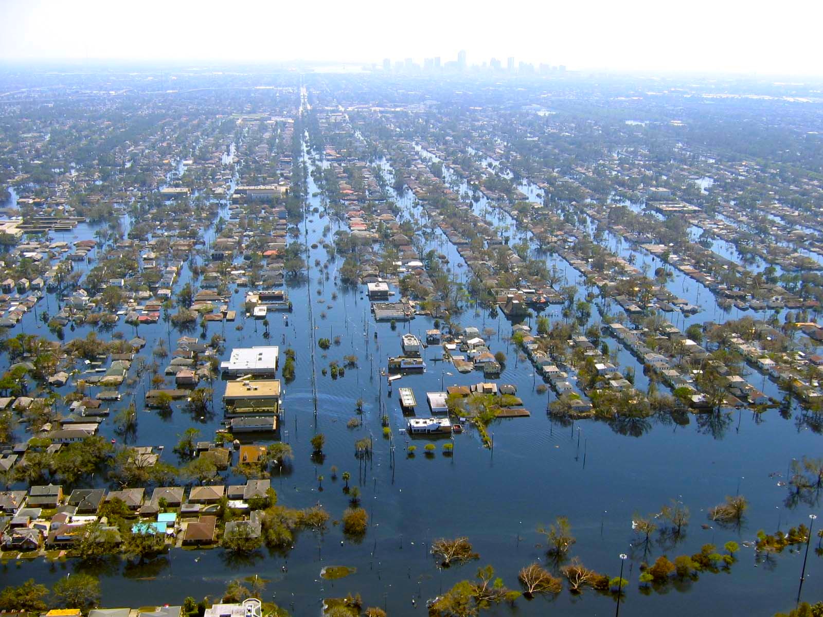
3. New Orleans and Cajun Country – Already a victim many times of extreme weather events including Hurricane Katrina, rising sea levels compounded by the sinking of the Mississippi River delta, denuded of its protective coastal wetlands by human engineered channel digging. Current forecasts indicate that southeastern Louisiana will be under the Gulf of Mexico by the year 2100. The current estimate is a combined rise and subsidence equalling 1.3 meters (4.3 feet). This is a coastline sinking faster than the seas are rising at a rate between 9.24 and 11.2 millimeters (1/3 to 1/2 inch) every decade.
In the draft report issued by the U.S. Global Change Research Program, a federal advisory body, it states that the combination of the sinking delta, thermal expansion of the Gulf of Mexico, and the melting of land and sea-based ice will cause massive innundations here before most other areas in America. So say goodbye to Mardi Gras, the French Quarter and the Garden District of New Orleans along with the bayous and Creole communities of the Mississippi Delta.
4. South and North Carolina, Charleston, Fort Myers, and the Barrier Islands where the Wright Brothers first flew – The last time my wife, daughter and I visited Charleston, South Carolina, it rained and the entire downtown quickly became inundated with almost a third of a meter (1 foot) of water. Apparently this is a common occurrence in this historic and beautiful city. But as sea levels rise it won’t be rainwater that the people of Charleston will have to pump from their basements and city streets. It will be the North Atlantic.
Situated along the storm track of North Atlantic hurricanes, this coastline is subject to extreme weather regularly. But with climate change those storm surges will be that much larger. The barrier islands are most vulnerable. Those bicycle rides on the pristine, flat beaches will be no more. The Museum at Kitty Hawk, North Carolina will be marooned at sea or underwater.
Currently the state governments here are frantically building new seawalls in the hope they can protect shoreline communities until the end of the century. But the seawalls are built behind the beaches.
In a recent article entitled, “South Carolina’s Solution to Sea Level Rise: Build More Walls,” Emily Atkin, the author, states “the state faces an average temperature rise of as much as 9 degrees Fahrenheit [5 Celsius] over the next 70 years. Along with the heat would come increases in wildlife disease, loss of habitat for wild game, degradation of the state’s valuable recreational and commercial fisheries, and – unsurprisingly – sea level rise, saltwater intrusion, and beach flooding.” And South Carolina’s government continues to deny climate change.
5. Washington, DC and Chesapeake Bay – Visits to the American capital and Tidewater Virginia have always been a fun experience for my family. But what happens to this part of America in the next 30, 50, or 70 years? The picture I have described for Southeastern Louisiana holds true for Chesapeake Bay. This is an area of America where the combination of rising sea levels and subsiding coastal areas will result in much larger changes. One contributing factor to the sinking of the Chesapeake region is the rise in population and drawing of freshwater from underground aquifers. This is putting much of the Delmarva Peninsula and the Virginia Coastal Plain at risk. Subsidence in some areas is being measured at rates as high as 4.8 millimeters (almost 2/10s of an inch) per year. Loss of coastal wetlands is further contributing to the disappearance of coastline.
For the American capital the threat of climate change is expected to impact freshwater supply with climate models projecting by 2040 a 35% decline in the Potomac as a water source. Washington, like the Carolinas will see much higher mean temperatures. And if I can remember from past visits to the nation’s capital in the summer, the place is already so hot and steamy you could fry and egg on the pavement in the noonday Sun. What will an additional average rise of 5 Celsius (9 Fahrenheit) degrees do to those planning a visit?
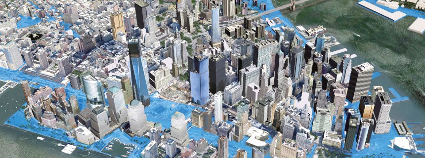
6. New York City, the Statue of Liberty, Ellis Island and the beaches of Long Island – New York and Long Island have been a destination for me in both my work and leisure life. I spent a number of years working for companies with headquarters here and have driven the length of Long Island all the way to the Montauk Lighthouse at the very eastern tip. So in looking at climate change and what it will do to this part of the U.S. east coast I want to cry.
In November of 2012 I wrote about the plan for New York and Long Island and what it will take to survive extreme weather event like Sandy combined with rising sea levels. New York has been tracking sea level rises for over a century. In 2012 after Sandy the city took action with a plan to harden its infrastructure looking at 900 kilometers (520 miles) of coastline most vulnerable to storm surges. The City has plans to protect its most critical infrastructure components from subways to the power grid and freshwater resources. It has proposed flood gates strategically located to control flooding. Inventors have come up with inflatable plugs to block seawater from flooding the subway system. Buildings are being retrofitted with renewable and standalone power systems should the grid fail.
But as good as these plans are New York City won’t be able to save the Montauk Lighthouse, and probably Liberty Island and its famous statue, or Ellis Island where so many Americans first landed as new immigrants.
I have limited the posting today to just those areas along the eastern seaboard of the U.S. that will be most impacted by the climate change happening now and over the coming decades. Climate change from the carbon already pumped into the atmosphere will be with us for a number of centuries. Most of us won’t experience its worst impacts in our lifetime. But our children’s children will.
What we will experience if we live to mid-century will be unsettling but manageable. What our descendants will experience by 2100 will be downright uncomfortable. And beyond 2100 so much of what I have described above will be experiences our descendants will do virtually, or will read about in e-literature. Their tours will show what Disneyworld was like and where the first Americans were launched into orbit. They will visit a virtual display of an anti-bellum Charleston or the French Quarter and Garden Districts of quaint and beautiful New Orleans.
Why? Because these places will have ceased to exist.