
August 2, 2019 – At this year’s Collision conference I was introduced to Tom Rump, CEO of Mesuri.io, the developers of The Earthstream Platform, a monitoring and management technology designed for microclimate conditions. In other words, farms. Rump told me that Mesur.io will change the way we measure and interact with the environment, helping us to make better decisions about what is grown, how soils are managed, how water is used, and more.
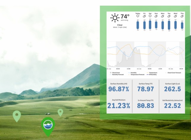
Founded by Mike Prorock, the owner of a farm in Chapel Hill, North Carolina, The Earthstream Platform was his way to help him with his business. Using a number of wireless, solar-powered sensors, tied into a hub with an application interface (see image below), Earthstream can see local condition details like soil moisture and temperature, measure light levels, track growing degree days, and more.
For farmers, ranchers, golf course and park managers, and other land parcel requirements, Earthstream assesses what is happening in the environment in real-time.
Earthstream gathers data from multiple sensors on the land and even data collected from drone overflights. It also tracks weather service information and fuses this with real-time local weather data to provide a local, accurate picture of the environment. Information is continuously updated providing automated alerts, detailed data analysis, and recommendations. It will tell you if you are using too much or too little war. It will tell you the health of your turf, your crops, your soil and subsoil depending on what package of sensors are in place on the property.
In a recent presentation at the United Nations, Mesur.io brought along a living garden to showcase Earthstream. It was an instant hit.
So why is what Mersur.io is doing so important?
On the website it uses these words
“Give the Earth a voice.”
It seems an appropriate phrase in the age of anthropogenic climate change, because how we interact with the planet will be the key to its and our survival.
In a recent report aired on CNN, we were told that humans are using 1.75 Earth-equivalents each year in terms of what we take from this planet. Knowing this, our ability to measure the planet’s health, and biodiversity for every hectare of land is critical. And being able to do it in micro-detail, means we can get more out of each hectare, and do it sustainably because we have the data measures for all that is necessary for sustainability.
So what started off as an individual farmer trying to manage a Chapel Hill farm has turned into a tool for all of humanity in our mission-critical task to maintain our planet and the life on it.
With a real picture of the planet’s cycles, “from germination to consumption,” it gives us the means to put the important numbers next to our practices and measure our progress.