
September 9, 2015 – In Erik Larson’s recreation of the events of September 8, 1900 in Galveston, Texas, we are immersed in a story of devastation in the face of lack of knowledge and preparation. The nameless hurricane in Larson’s tale, Isaac’s Storm, struck what was then the second largest eastern port in the United States. In one day, Galveston’s promising future was gone as a storm surge submerged almost the entire city.
The Galveston storm occurred during the fledgling years of the American National Weather Service, an arm of the U.S. military. Weathermen learned to ride horseback and did endless parade ground marching drills. Some even knew how to read a barometer and anemometer. Hurricane science was new. American weathermen resident in Cuba paid little attention to the Cuban equivalent weather bureau whose personnel tracked the storm as it crossed the island predicting it would strike Texas. The Americans had the storm veering northeastward across the Florida straits and up the Atlantic coast. They were wrong.
For the thousands who died 115 years ago yesterday it would have been important to have had advanced warning based on accurate forecasting. But hurricane tracking and reporting was still in its early stages and even with a reliable weatherman on the ground in Galveston that day resources were insufficient to help move people inland in time.
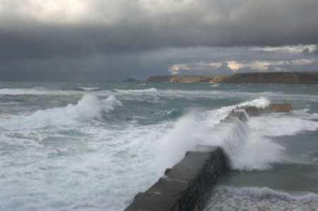
Now go back a mere 10 years to Hurricane Katrina as it was tracked across the Gulf of Mexico with precision and projected to come ashore close to New Orleans. All that knowledge and all the infrastructure built to withstand storm surges proved incapable of stopping the city from experiencing a similar devastating storm surge like the one that struck Galveston 105 years earlier. In New Orleans we had levees, flood barriers, canals and massive sump pump drainage systems to push the water back out to sea. Didn’t work!
In the past few days the United Nations Office for Disaster Risk Reduction (UNISDR) has released data on extreme weather events since the year 2000 recording 1,215 occurrences impacting 1.2 billion people. The report with data from 1970 to 2011 indicates that more than 2 million have died in these extreme events. Most who died lived in coastal urban centres like New Orleans. Most vulnerable to date are Asian cities, the fastest growing demographic on the planet. It is expected between now and 2050 that rural to urban migration globally will further concentrate humanity in fewer and bigger cities. So what this means is extreme weather events becoming even more extreme in impact. For Asian cities equivalent to New Orleans, therefore, new investments need to be made in not just weather tracking and flood forecasting, but also in infrastructure to mitigate threats from storm surges. Finding the money is not easy because of competing demands for food, energy and housing in these developing nations. But nevertheless investment is seen as necessary.
Why? A new study appearing in Nature Climate Change on August 31, 2015 provides an answer. The research looks at predictability of “grey swan” tropical cyclones. These are storms currently capable of generating 6 to 7 meter (20 to 23 foot) surges in vulnerable coastal areas. Modeling the atmosphere through the remainder of the century shows significant increases in grey swan frequency from current event likelihood of 1:10,000 to 1:700. The models also indicate surges will grow to as high as 11 meters (36 feet). That’s as tall as a three-storey building.
In another study appearing in Geophysical Research Letters, NASA and University of California Irvine researchers discovered a link between the size and distribution of Amazon wildfires and frequency of hurricanes in the Atlantic. When the Amazon burns the normal atmospheric river created by evaporation from the rainforest gets altered. A disrupted water cycle means less moisture in the air to form clouds over the ocean. That means surface water receiving more heat energy from the Sun. Voila, the means by which hurricanes form – dry winds blowing from Africa, a warm ocean, massive water redistribution into the air and the beginnings of what could be the next Katrina or Sandy.
Related articles across the web


Related Posts
 Investing In Space Ventures Is Hot Right Now
 Climate Change And Mental Health: Both Are Getting Worse
 If You Are Using Semaglutide Drugs to Lose Weight Are You Hooked on Them for Life?
 Banana Monoculture Is At Risk Without GMO
 Daylight Savings Time, Standard Time, Is There Science Behind Our Twice Annual Shift?
 The Saga of Honeybee Colony Collapse is Being Questioned
 Conversations About AI: A University-Level Guideline for Its Ethical Use
 Another Potential Battery Breakthrough That Uses A Water Electrolyte


