I couldn’t miss the opportunity to memorialize RMS Titanic in this blog on the 100th-year anniversary of it sinking. Could it happen again? Could a ship hit an ice berg and sink?

In light of the Costa Concordia sinking in the Mediterranean, maritime safety is once more a front page headline. But ice bergs are no longer the threat they once were. And with the melting of the Arctic sea ice becoming more extensive each year it appears that many more ships will be plying Arctic waters in the near future.
So what is the difference between now and 1912? Satellites and vigilance. After Titanic sank world governments established the International Ice Patrol (IIP). This international body has been monitoring ice bergs in the Arctic, North Atlantic and Antarctic Oceans since.
What is the definition of an ice berg as opposed to sea ice? An ice berg officially is an ice-cube-sized chunk larger than 5 meters (16 feet) in diameter. The IIP tracks ice bergs larger than 500 square meters (5,400 square feet). At any time there are as many as 100,000 of these chunks of ice bobbing in the waters of the Davis Strait and North Atlantic Ocean. They ride the cold currents southward remaining largely intact until they hit the warmer waters of the North Atlantic Drift and Gulf Stream where thousands of ships regularly ply the waters. The ice bergs become unstable as they melt, constantly tumbling and shifting while breaking apart.

Before the onset of airplanes with the capability of traversing the Atlantic, ships regularly sent information to the IIP to monitor the position of ice bergs to warn other vessels about potential danger. Since its inception IIP warnings have proven highly effective. But the technology to track sea ice has changed. Airborne sightings supplemented ship observations. Then radar data further provided a picture for ships in North Atlantic waters. Satellites have become another tool in tracking ice berg locations.
A new European Space Agency program will operate a number of satellites, named Sentinel. To be launched into polar orbit these spacecraft will provide Earth obsevation from using synthetic aperture radar (SAR). The satellites will monitor sea-ice zones in the Arctic, map land surfaces and usage, ice and land surface movement, and general surveillance for the tracking of any potential humanitarian crises.
The satellites will provide all-weather day and night surveillance capability. Surface movements of ice and land masses will be detectable to within a few millimeters per year. The Sentinel project will track the impact of landslides, earthquakes and glaciers as well as the movement of sea ice.
The satellites will revisit the same 250 kilometer-wide (155 miles) swath of the Earth every 12 days. The first two satellites are scheduled to launch in 2013.
Related Posts
 Was Carl von Clausewitz Right Describing War as a Form of Policy?
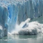 Adjusting Time as the Polar Ice Caps Melt Causing Earth Spin Rate to Change
 Have We Learned Anything From The COVID-19 Pandemic?
 Can Kinetic Energy Harvested From Human Activity Help Save The Planet?
 Virtual and Augmented Reality Update: Apple Vision Pro and the Metaverse
 Will AI Disrupt the Practice of Medicine? Absolutely
 Conversations About AI: A University-Level Guideline for Its Ethical Use
 Solar Energy is Popping Up in Some Very Unusual Places


