November 20, 2016 – Yesterday the United States launched a weather satellite that was long overdue. Weather satellites are the eyes the world needs to track what is going on in the atmosphere of our planet. With them we can see nascent hurricanes and typhoons and plot their tracks. We can follow clusters of thunderstorms to warn those on Earth about imminent threats from tornadoes and other dangerous weather phenomena. Without them meteorologists are limited to weather observations using balloons and ground-based stations.
The new satellite, the Geostationary Operational Environmental Satellite-R or GOES-R (sounds like the pagan god in the first Ghostbusters), represents the state-of-the art with visual and infrared imaging, lightning mapping. GOES-R is the first of four planned to be launched between now and 2036. It joins a worldwide network of weather satellites from other nations that share data and imagery so that no part of the planet is left unobserved.
What GOES-R provides includes:
- Improved hurricane track and intensity forecasts
- Increased thunderstorm and tornado warning lead time
- Earlier warning of ground lightning strike hazards
- Better detection of heavy rainfall and flash flooding risks
- Improved aviation flight route planning
- Improved air quality warnings and alerts
- Better fire detection and intensity estimation
- Improved solar flare warnings for communications and navigation disruptions
- More accurate monitoring of energetic particles responsible for radiation hazards to humans and spacecraft
- Better monitoring of space weather to improve geomagnetic storm forecasting
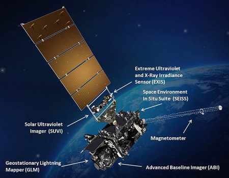
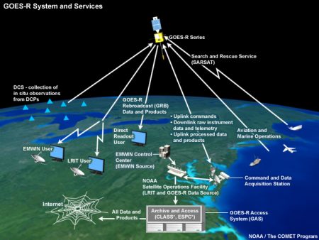
The on board instrument package includes The Advanced Baseline Imager (ABI) collecting three times more data, providing four times better resolution, and five times faster coverage than past GOES satellites; the first lightning mapper flown from geostationary orbit, The Geostationary Lightning Mapper, or GLM; a suite of space weather detection instrumentation acting as an advanced warning system for gamma ray bursts and geomagnetic storms from the Sun potentially impacting other satellites, humans on board the International Space Station, and utilities, communications and navigation systems on Earth. GOES-R communication instrumentation will relay data directly to users anywhere in the world and through the Weather Information Network it will provide continuous links to weather forecasters and emergency beacon detection on ships and airplanes.
GOES-R cost approximately $1 billion U.S. What do Americans get for those government-invested bucks?
The baseline operation which will begin within a year incorporates:
- Aerosol Detection (Including Smoke and Dust)
- Aerosol Optical Depth (AOD)
- Clear Sky Masks
- Cloud and Moisture Imagery
- Cloud Optical Depth
- Cloud Particle Size Distribution
- Cloud Top Height
- Cloud Top Phase
- Cloud Top Pressure
- Cloud Top Temperature
- Derived Motion Winds
- Derived Stability Indices
- Downward Shortwave Radiation: Surface
- Fire/Hot Spot Characterization
- Hurricane Intensity Estimation
- Land Surface Temperature (Skin)
- Legacy Vertical Moisture Profile
- Legacy Vertical Temperature Profile
- Radiances
- Rainfall Rate / QPE
- Reflected Shortwave Radiation: TOA
- Sea Surface Temperature (Skin)
- Snow Cover
- Total Precipitable Water
- Volcanic Ash: Detection and Height
- Lightning Detection: Events, Groups & Flashes
- Energetic Heavy Ions
- Magnetospheric Electrons & Protons: Low Energy
- Magnetospheric Electrons & Protons: Med & High Energy
- Solar & Galactic Protons
- Geomagnetic Field
- Solar Flux: EUV
- Solar Flux: X-ray Irradiance
- Solar EUV Imagery
Future planned software upgrades will provide additional capability including detection of:
- Absorbed Shortwave Radiation: Surface
- Aerosol Particle Size
- Aircraft Icing Threat
- Cloud Ice Water Path
- Cloud Layers/Heights
- Cloud Liquid Water
- Cloud Type
- Convective Initiation
- Currents
- Currents: Offshore
- Downward Longwave Radiation: Surface
- Enhanced “V” / Overshooting Top Detection
- Flood/Standing Water
- Ice Cover
- Low Cloud and Fog
- Ozone Total
- Probability of Rainfall
- Rainfall Potential
- Sea and Lake Ice: Age
- Sea and Lake Ice: Concentration
- Sea and Lake Ice: Motion
- Snow Depth (Over Plains)
- SO2 Detection
- Surface Albedo
- Surface Emissivity
- Tropopause Folding Turbulence Prediction
- Upward Longwave Radiation: Surface
- Upward Longwave Radiation: TOA
- Vegetation Fraction: Green
- Vegetation Index
- Visibility
All of that for $1 billion. It is no wonder that NOAA and NASA consider the satellite a game changer for the United States as well as the 200 countries that are members of the World Meteorological Organization (WMO). Reciprocally NOAA and NASA receive weather satellite and ground observation data from WMO members. This is a significant change states Richard Rood, Professor of Atmospheric Science, University of Michigan. He remarks, “The U.S. was originally the only global network, and then the Europeans, Japan and India all started launching their own satellites.” Today the WMO World Weather Watch network relays and shares global satellite and ground-based data providing a backbone for model forecasting and weather prediction. It makes sense since all nations hold the atmosphere in common. There are no geopolitical boundaries for the air. No place on the planet today cannot receive a 4 to 5 day advance warning of weather phenomena that potentially can be harmful.
GOES-R when it attains its final position will be parked in geostationary orbit 35,800 kilometers (22,300 miles) above the Earth looking both down and up. The satellite measures 5.5 meters (18 feet) in length, 1.8 meters (approximately 6 feet) in width, and weighs 2,800 kilograms (over 3 tons). Once operational its designation will change from GOES-R to GOES-16. Its other designation is GOES-West because it covers the Western Hemisphere downloading imagery and data every 30 seconds.
The Director of Satellites at the NOAA , Stephen Volz, describes the GOES-R program as “a quantum leap.” It means “more lives saved and better environmental intelligence for government officials.” The difference of a few minutes warning about a tornado or the accurate tracking of a hurricane’s path well ahead of landfall will save thousands of lives and billions of dollars.
The next in the series of 4, GOES-S is scheduled to launch in 2018. The remaining two are designated GOES-T and GOES-U.
Operationally NOAA maintains two weather satellites in orbit at all times with a backup should a problem occur. The first GOES, designated GOES-A dates back to the 1970s. GOES-R marks an unbroken chain of continuous weather satellite coverage going back to then. It will be the Western half of a GOES duo with an in-orbit spare available should either of the two GOES fail. In the past this has happened. For example in 2013 a micro-meteoroid took out GOES-13 and GOES-14 was quickly maneuvered into position to take over. And in 1989 a predecessor GOES also failed with a Europeans weather satellite over the Atlantic Ocean repositioned further west to fill the gap until the United States could launch a GOES replacement.
One wonders as the new American administration begins dismantling the Environmental Protection Agency of which NOAA is a part, what will potentially happen to the GOES-R program. What will happen to the international cooperation among WMO nations? After all much of what GOES-R and other weather observation satellites do observes and validates global warming and climate change.
Related Posts
 Why Do Conservatives Reject Market-Driven Carbon Emission Pricing?
 Daylight Savings Time, Standard Time, Is There Science Behind Our Twice Annual Shift?
 Why Am I Left-Handed? Blame Tubulin Proteins for This Asymmetric Brain Twist
 Hydrogen From Ammonia or Ammonia Itself May Power Our Future
 When You Need Portable Energy Storage: A Bluetti EB3A Could Be Your Answer
 Carbon Pollution Pricing Seemed Like A Good Idea A Decade Ago
 U.S. Using A Supercomputer To Help Communities Model Climate Risk
 Virtual and Augmented Reality Update: Apple Vision Pro and the Metaverse


