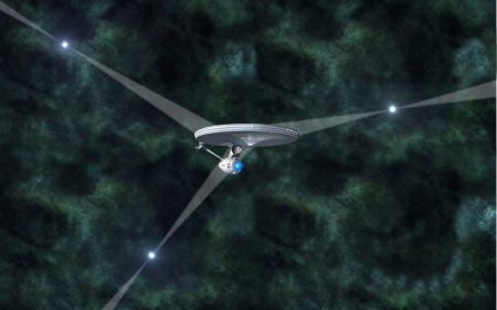
August 11, 2016 – The National Physical Laboratory (NPL) and University of Leicester, in the United Kingdom, published a paper this week describing the equivalent of a GPS system for use by interplanetary spaceships. The paper, entitled, “Towards practical autonomous deep-space navigation using X-Ray pulsar timing,” appears in the journal, Experimental Astronomy, and describes a deep-space navigation system relying on the signals emitted by X-ray pulsars captured by an XNAV on board instrument.
What is a XNAV? It’s a small X-ray telescope that tracks the position, velocity and timing of reliable pulsars. Pulsars are rapidly rotating neutron stars, stars that have erupted in the past into super novae leaving an inner core approximately 20 kilometers in diameter with a mass greater than our Sun. According to their namesake these remnants are largely composed of neutrons. They rotate with a periodicity that can vary but in some cases the rate is predictable. In rotation they emit X-ray pulses that can be timed and used as a beacon for celestial navigation.
Triangulating on three pulsars resembles the way GPS works here on Earth. A GPS system relies on three passing satellites to triangulate the position of your car as you drive down a road. Now a spaceship with an on board XNAV can do the same with pulsars and accurately plot its position in space.
The current accuracy of the XNAV created by NPL and the University can place a spacecraft within 2 to 5 kilometers of its celestial position. Now that sounds like a big miss but when you are talking about distances in Deep Space, that’s close enough for a spaceship with other navigational instruments to make course adjustments to correct the distance error.
The XNAV will soon be tested in space with plans to include it on board for a European Space Agency mission to Mercury scheduled for 2018. If successful it will replace the current European Space Tracking (ESTRACK) network and NASA’s Deep Space Network which can take several hours to plot the accurate position of a spacecraft on a mission to the outer planets of the Solar System.
Related Posts
 Transforming Coffee’s Future With Bioreactors And Cell Power
 It’s the Middle of February and I Just Came in From Sitting on My Balcony
 Conversations About AI: Will Human Software Coders Soon Be Obsolete?
 Should the U.S. Power Grid Move Underground?
 Dark Matter and the Cosmic Web in the News
 Earth Day 2024 And The Atmosphere Is Raining Microplastic
 Canada is Becoming a Nuclear Fusion Hotbed
 Leap Day is a Good Time to Look How the Sun, Moon and Earth Mark Time


