
November 15, 2019 – Peter Diamandis in a recent email blast describes how 21st-century technology is changing disaster management. This is not Peter’s first go at this subject since I recall posting content from him in the past of a similar nature. But it is worth revisiting to see what else he has uncovered.
In the past 50 years, the frequency of natural disasters has increased by 500%. From 2005 to 2014, more than 700,000 people died in natural disasters around the world. Besides their death, the damage inflicted from these events amounted to $1.4 trillion USD.
Among the types of natural disasters recorded were wildfires like the ones that have created a new season called “fire seasons” in countries like Portugal, Spain, Australia, Brazil, and provinces and states such as British Columbia, and California. One might question calling wildfires natural disasters since human behaviour, not just droughts is a strong contributing factor. Nonetheless, the need to develop prevention and rapid response to these events has never been more needed particularly since human population growth has increasingly encroached on the natural world.
I have taken the liberty to edit the raw material Peter has sent but have stayed true to his intent as he describes the development of technologies such as artificial intelligence (AI), robotics, drones, sensors, and smart networks and their application to preventing, predicting, and responding in the first hours to help victims of these events. In this posting he looks at three technology groups specifically. They include:
- AI, predictive mapping, and crowdsourcing
- Next-gen robotics and swarm solutions
- Aerial drones and immediate aid supply
Artificial Intelligence and Predictive Mapping
When it comes to immediate and high-precision emergency response data is gold. We are witnessing the deployment of global space-based telecommunications networks and the rollout of 5G with the potential to connect every individual on this planet. Aside from democratizing the world’s information the upsurge in connectivity will soon grant anyone the ability to broadcast geotagged data, particularly useful in the face of a natural disaster. This is crowdsourcing that can play a vital role in emergency response, turning historically one-way blind rescue operations into a two-way dialogue between connected crowds and smart response systems.
With this skyrocketing abundance of data comes a new paradigm, one in which we no longer face a paucity of answers. Instead, it will be the quality of our questions that matter. And this is where AI comes in. What if we could map all incoming data points, or predict the dynamics of a flood, identify a tsunami’s most vulnerable targets, or plot the path of a storm? Through the power of volunteer crowdsourcing we can create relatime information updates to help optimize crisis response.
One Concern’s Predictive AI for Urban Disasters
Born out of Stanford University under the mentorship of leading AI expert Andrew Ng, One Concern is a using AI machine learning to predict and quantify the impact of natural disasters, and to build more resilient businesses, infrastructure, and global communities. Partnering with the City of Los Angeles, San Francisco, and numerous places in San Mateo County, One Concern assigns verified, unique digital fingerprints to every location. It builds robust models of each system and then monitors site-specific impacts from climate change, seismic movements, and other natural disasters. It combines this data with legacy-created data about city infrastructure and former disasters, and then uses all of it to predict future damage under a range of disaster scenarios along with advice on prevention and mitigation. In its four years of existence, One Concern can now use its AI to make precise predictions with 85% accuracy in less than 15 minutes.
Utah University’s Forest Fire Predictive AI
Adam Kochanski and a team of researchers at Utah University are developing an AI forest fire mapping algorithm built using historic and new data to predict how fires spread and what weather events follow in their wake. The team has used predictive forest fires (set deliberately for the purpose of spurring forest regrowth) accompanied by infrared-camera-fitted drones, laser scanners, and sensors to collect data to build a predictive model. The experiment is contributing to “coupled fire-atmosphere models,” which leverage collected data to predict how wildfires influence local weather conditions and the interaction that occurs between the fires and spawned weather. Kochanski’s model is proving to be remarkably accurate in predicting wildfire behavior. It is hoped that the tool will help to stem early fires before they gain momentum, saving forests, lives, property, and entire ecosystems.
Spatial Web Technology Takes Crowdsourcing to a New Level
The spatial web isn’t limited to a set of wired access points and wireless hotspots. The spatial web acts as a mesh network connecting entire cities using hundreds of dispersed nodes that communicate with each other and share a network connection non-hierarchically. This puts the power of networking and crowdsourcing intelligence into the hands of every smartphone user.
How can this be used?
Imagine a scenario in which armed attacks break out suddenly across different parts of a city. Clusters of eyewitnesses and at-risk civilians can broadcast an aggregate of 360-degree videos, all fed to a photogrammetry AI that builds a live hologram of the ongoing events to give first responders and those potentially affected a complete visual map.
A coastal community in the throes of torrential rainfall leading to flooding and failed infrastructure can have eyewitnesses collecting live feeds that can be combined with existing maps and data to provide first responders with accurate reporting to specify where relief is needed first. Drones tied into the crowdsourced intelligence could be directed to provide live video feeds, while swarms of drones and robots could gather emergency supplies, and deliver them to where they are needed. This scenario leads us to our next subject.
Autonomous Robots and Swarm Solutions
As hardware advancements converge with exploding AI capabilities, disaster relief robots are graduating from assistance roles to fully autonomous responders at a breakneck pace. Born out of MIT’s Biomimetic Robotics Lab, the Cheetah III is but one of many robots that could form a first line of defense in everything from earthquake search-and-rescue missions to high-risk operations in radiation zones. The Cheetah III can run at a speed of 6.4 meters per second
Now capable of running at 6.4 meters (21 feet) per second, and leap heights of 60 centimeters (approximately 2 feet), doing obstacle avoidance autonomously.

Initially designed to perform spectral inspection tasks in hazardous settings such as nuclear powerplants or chemical factories, the Cheetah III’s various iterations focus on increasing payload capacity, extending range of motion, and even adding an arm for dexterity. As explained by Associate Professor Sangbae Kim, of MIT, the Cheetah III, and future versions is and will be aimed at saving lives in almost any environment. Kim says, “Let’s say there’s a fire or high radiation, [whereby] nobody can even get in. [It’s in these circumstances that] we’re going to send a robot [to] check if people are inside. [And even] before doing all that, the short-term goal will be sending [the] robot where we don’t want to send humans at all, […] for example, toxic areas or [those with] mild radiation.”
Cheetah III is not alone. In February this year, Tokyo’s Electric Power Company (TEPCO) put a robot to the test in the Fukushima nuclear power plant that was heavily damaged in the 2011 tsunami. The robot was able to enter the reactor to retrieve chunks of radioactive fuel at five of six test sites, offering promise for long-term planning to clean up the still-deadly interior.
And Japan’s Mitsubishi Heavy Industries (MHi) is using robots to fight fires autonomously. The MHi Water Cannon Bot can put out blazes in difficult-to-access or highly dangerous fire sites delivering foam or water at 4,000 liters per minute and 1 megapascal (MPa) of pressure. The Cannon Bot and its accompanying Hose Extension Bot form part of a greater AI-geared system. As wildfires grow more untamable, using bots like these could prove a lifesaver. Paired with the predictive AI forest fire mapping described earlier, and delivered to fire sites by autonomous vehicles, solutions like the Cannon Bot means pre-emptive measures will limit fire outbreaks and fewer human firefighters can focus on search and resuce while robots like the Cannon Bot can handle the flames.
And then there is the robot that can build emergency shelters as needed during times of natural disasters. The Hadrian X, from Fastbrick Robotics, can build a fully livable, 180-square meter home in less than three days all on its own using 3D modeling, a robot arm, and a supply of bricks.
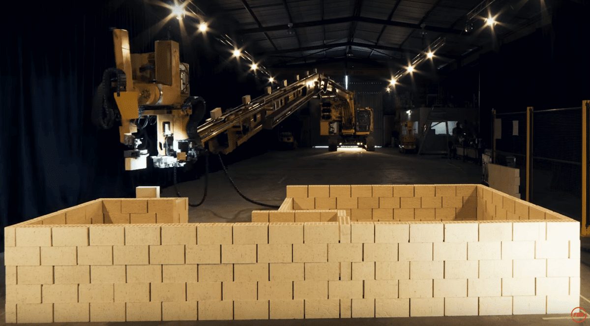
Imagine deploying the Hadrian X and similar autonomous solutions in post-disaster and conflict sites to help with recovery.
But in the absence of bricks a new 3D printing robot called Pylos, developed at the Institute of Advanced Architecture of Catalonia (IAAC), converts almost any soil into building material with three times the tensile strength of industrial clay. Offering myriad benefits, including natural insulation, low greenhouse gas emissions (GHGs), fire protection, air circulation, and thermal mediation, Pylos can build a house on-site for material costs of as little as $1,000 USD.
Next-Generation Relief and Supply Drones (UAVs)
Autonomous drone technology is fundamentally revolutionizing the way we find survivors in need and automate relief supplies. Using high-resolution imagery for real-time mapping and damage assessment, UAVs can far outpace any ground-based rescue team in locating isolated survivors. Drones in China are even being used to build a temporary mobile wireless broadband network in the event of a disaster with the drones acting as cell towers.
Drones have helped assess flood damage in the aftermath of Hurricane Harvey. Texas A&M during Harvey flew 119 drone missions over the City of Houston using them to monitor levee infrastructure and to identify those in need of rescue.
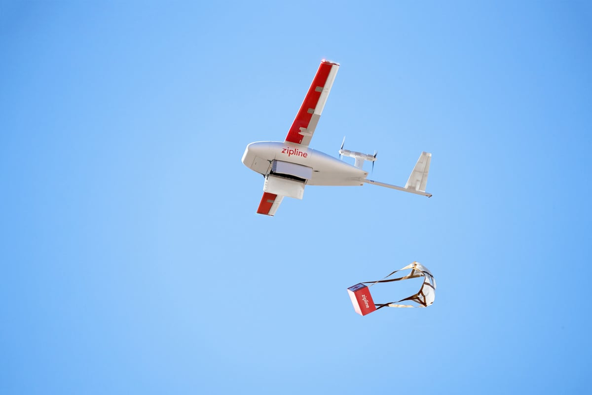
But beyond surveillance, UAVs have begun to provide lifesaving supplies across some of the most remote regions of the globe. Take for example Zipline which has been used in places like Costa Rica, Rwanda, and Tanzania to deliver medical supplies from vaccines to HIV medications, to blood and intravenous tubes. Zipline has proven it can outpace ground-based supply transport to provide critical supplies in less than an hour.
There are even drones capable of delivering much larger payloads. Under contract with DARPA and the U.S. Marine Corps, Logistic Gliders, is building autonomous drones capable of carrying payloads of up to 816 kilograms (1,800 pounds) over long distances. The gliders are built out of plywood and cost a few hundred dollars to produce making them perfect candidates for high-volume, remote aid delivery. They can be navigated by remote control using a human pilot, or fly on their own based on disaster zone mapping data.
Concluding Thoughts
One of the most consequential and impactful applications of the converging technologies described above is their ability to transform disaster relief methods. AI-driven intelligence platforms, crowdsourced firsthand experiential data, mobile connectivity, and drone-supplied networks are granting newfound narrative power to those most in need. And as new hardware advancements give rise to robotic responders, swarm technology and aerial drones, we are fast approaching an age of instantaneous and efficiently distributed responses in conflict zones and in the aftermath of natural catastrophes.