
February 5, 2019 – The United States Bureau of Land Reclamation reported this week that the Colorado River has reached a climate tipping point as global warming continues to dry up areas of the Western U.S.
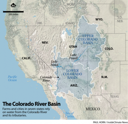
The river is slowly dying because the sources that feed it are receiving less precipitation, and because of agricultural, urban and industrial water being drawn from it. Seven U.S. states compete for water rights along the Colorado, as do Indigenous American tribes, and Mexico. The jurisdictions from south to north are Mexico, California, Arizona, Nevada, New Mexico, Colorado, Wyoming, and Utah.
Since 2000 the Southwestern United States has experienced temperatures above normal causing excessive evaporation in the Colorado River basin from the snowpack sources, tributary streams, and the two artificial lakes created behind the Hoover and Glen Canyon Dams. Both Lake Mead and Lake Powell have seen dramatic drops in water levels over this period of time. A recent study calculates the drop in flow by as much as 19% below pre-2000 levels.
With current global mean temperatures having risen 1 Celsius (1.8 Fahrenheit), that translates to a 10% decline from norms in the mountain snowpack. And each additional degree will see that decline grow even further, something climatologists believe will happen well before 2070 even if global greenhouse gas emissions are reduced from current levels. The latency of accumulated greenhouse gases in the atmosphere will put the entire Colorado River basin at risk with significant river flow declines.
Scientists no longer call what is happening in the U.S. West as drought or megadrought. A new term, aridification, they believe is a better descriptor. That’s because the U.S. West in the age of climate change is overall becoming drier and that means the mountain snowpack is migrating to higher elevations and declining in size.
States Doug Kenney, Director of the Western Water Policy Program, University of Colorado – Boulder, the Southwest will have to learn to live with less water. The threats to Lake Powell and Mead aren’t just about the water. They are also about the power generation that comes from the hydroelectric facilities that rely on the head, the vertical drop in elevation created by the reservoir that creates the forces to drive the turbines to generate electricity. If the water levels in these dams drop below a critical level, it will expose the water intake and leave the penstocks, the pipes that channel the water, high and dry.
On January 24, the Salt Lake Tribune reported that Lake Powell may be doomed. One proposal has farmers selling their water rights back to the federal government and giving up farming to ensure there is enough water in the reservoir behind the Glen Canyon Dam so that the hydroelectric facility can remain online.
A drought contingency plan for Lake Mead includes mandatory cutbacks to water use from the farms, communities, and cities that rely on the river basin. That includes Las Vegas, Phoenix, and Los Angeles. The future of this part of the United States and its prosperity is tied to the Colorado. Without reductions in water usage from the seven states that share the basin along with Mexico, this part of America may produce climate change migrants who will be moving north and east to find a sustainable future.