Weather whiplash is a new term to me but it connotes an image of being pummeled and pulled by constant changes. Think of it as the weather doing a complete 180-degree turn rapidly. I’ll give you two personal and three recently reported examples.
- On a working trip through Western Canada, I experienced a whiplash event in Winnipeg, Manitoba. I almost froze to death waiting outside for a taxi in the late afternoon after heading out from my hotel that morning wearing a light coat because the forecast said balmy temperature conditions.
- On that same trip, I was in Calgary, Alberta, where another rapid temperature swing in reverse occurred with me bundled up because of a freezing-cold-with-snow morning, and sweating in the afternoon as unseasonably warm and dry air descended from the Rocky Mountains, a phenomenon known as a Chinook. They are called snow eaters and I was able to observe first hand why that name applies.
- Last December in Minneapolis, Minnesota, temperatures for the month were 7 Celsius (14 Fahrenheit) warmer than normal. In January they fell below seasonal norms of daytime highs of -5 Celsius (23 Fahrenheit) and lows of -13 Celsius (9 Fahrenheit). By the end of the month Minneapolis was in the mid-teens Celsius (the mid-50s Fahrenheit).
- Bozeman and other cities in Montana, this January, saw temperature swings of 55 Celsius (100 Fahrenheit) with rapid snow melt, described by locals as “a remarkable feat.”
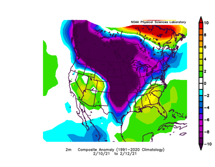
- Houston, Texas, saw low temperatures last month drop to -7 Celsius (19 Fahrenheit) and then reverse to above sub-tropical norms hitting in the mid-20s Celsius (75 Fahrenheit). In February 2021, a whiplash freeze event (see map above) killed 246 and caused $200 billion in damage to the state’s utility grid and other infrastructure.
This phenomenon called weather whiplash is here to stay around the world because of atmospheric warming from rising levels of carbon dioxide and other industrial greenhouse gas emissions. It is making rapid and extreme changes in weather the new reality, producing dramatic temperature swings, and sudden changes in precipitation patterns, wind speeds, and atmospheric pressure. Long droughts get interrupted by atmospheric rivers like the one that hit California recently leading to flash floods and the destruction of crops. Warm spells that confuse plants to start germinating and flowering only to be interrupted by flash freezes. Blizzard-like snowstorms that bury cities and towns such as has happened in Atlantic Canada in the last week, disrupting power, blocking highways, and more.
Identifying and measuring weather whiplash has only recently become a subject of study. Whiplash event metrics are still being defined. Called WWEs which stands for Whiplash Weather Events, senior scientist at the Woodwell Climate Research Center in Falmouth Massachusetts, Jennifer A. Francis, and a team of researchers are trying to characterize, quantify, map and predict the phenomenon. They are studying continental-scale shifts in patterns in the Jet Stream in the Northern Hemisphere.
Jet Streams can be found in both hemispheres. They are wind currents found at altitudes where jets fly and occur over land and water. Their paths are sinuous and often take dramatic swings. They steer high and low-pressure systems. The Northern Jet Stream when it swings far south allows Arctic air masses to cause extreme cold in places like Texas. When it swings north it allows warm air to reach places like Minnesota and Montana.
Francis and her team are tracking WWEs. She has authored several research papers on the subject. The latest appeared last December in the journal npj Climate and Atmospheric Science, describing an applied approach to diagnose and track WWEs over Europe and the North Atlantic, identifying variations in type and duration and correlating these to observed changes to the Jet Stream stating “when a persistent, distinct circulation pattern shifts to another substantially different one, the weather also changes, often dramatically.”
Francis has applied a neural network-based pattern recognition tool (a type of Deep Learning AI) previously used for medical applications to analyze atmospheric behaviour. The goal is to accumulate WWE data from the past and find patterns to determine future behaviour on a continental scale.
One trend gleaned from the research shows the frequency of WWEs is on the increase whether abnormal bouts of warmth or cold, onslaughts of heavy precipitation or dry periods, wind events and more. There is less business-as-usual in weather these days and the historical data from 1979 through to 2005 shows it. The latter years of that period show WWE tracking upward with more significant occurrences in summer months initiated by amplified Arctic warming.
The research has produced self-organizing maps as tools for assessing continental-scale changes in the Jet Stream associated with WWEs and other disruptive weather conditions. The research forecasts WWEs likely to increase in frequency over Europe and the North Atlantic. It predicts an increase in heat waves in Greenland offset by colder-than-normal conditions in Northern Europe and increased heavy precipitation events in Central Europe and the Mediterranean.
Francis plans to use the neural-network tool to study WWEs in other parts of the planet to better understand their history and characteristics and provide a degree of predictability to enable decision-makers, farmers, utilities, and the general public to make preparations to lessen their impacts.


